SD2

SD2 - Cli­ma­tic con­trol on lar­ge-sca­le se­di­men­ta­ry struc­tu­res


                                                                                                                                                                                                                                                                                                                                                                       T. Schwenk, T.J.J. Hanebuth, T. Mörz, D. Hebbeln, R. Henrich

A. Bar­tho­lo­mä, M. El­vert, A. Frei­wald, D.A. Hepp, S. Kas­ten, H. Keil, H. Lantzsch, H. Mül­ler, F. Ober­le, M. Stras­ser, V. Spieß, T. v. Do­ben­eck


The se­di­men­ta­ry sys­tems of con­ti­nen­tal shel­ves and slopes host va­rious lar­ge-sca­le de­po­si­tio­nal and ero­sio­nal fea­tures who­se for­ma­ti­on pro­ces­ses are con­trol­led by se­di­ment flux, hydro­dy­na­mic con­di­ti­ons, sea le­vel, and lo­cal to­po­gra­phy (Nit­trou­er et al. 2007). All of the­se pa­ra­me­ters com­mon­ly in­ter­act with each other in a com­plex way and re­act stron­gly to cli­ma­tic con­di­ti­ons.

The ef­fect of cli­ma­tic for­cing on lo­cal­ly con­fi­ned depo­cen­ters (shelf mud belts, shelf sand fiel­ds, low­stand del­tas, slo­pe con­tou­rites), elonga­ted de­pres­si­ons (pa­leo-val­leys, slo­pe can­yons), and cha­rac­te­ris­tic ero­sio­nal fea­tures (fur­rows, scars) will be stu­di­ed by in­ter­di­sci­pli­na­ry ap­proa­ches. Ma­jor ad­van­ces sup­porting such stu­dies are pro­vi­ded through the MeBo sys­tem, which has al­re­a­dy been suc­cess­ful­ly ap­p­lied for SD stu­dies at the Uru­gu­ay mar­gin, and by the new­ly de­ve­l­o­ped GOST sys­tem pro­vi­ding in-situ geo­tech­ni­cal data.


SD2 Key Hy­po­theses


                                                                                                                                                                                                                                                                                                                                                                       Major transgressions cause significant reorganization of the entire shelf system that is best recorded in shelf-crossing paleo-valleys.

Our un­der­stand­ing of pa­leo- and mod­ern sed­i­ment dy­nam­ics re­lated to trans­gress­ive scen­arios is lim­ited due to the of­ten dis­con­tinu­ous nature of open-shelf sed­i­ment­ary re­cords. Pa­leo-val­leys formed dur­ing sea-level lowstands of­fer a great pre­ser­va­tion po­ten­tial for early trans­gres­sional sed­i­ment­ary se­quences (Green, 2009). Us­ing seis­mic, sed­i­mento­lo­gical, geo­tech­nical and nu­mer­ical mod­el­ing ap­proaches, trans­gres­sional sed­i­ment­ary se­quences will be in­vest­ig­ated fol­low­ing in the wake of the last de­gla­cial sea-level rise (Vink et al. 2007). Un­der­stand­ing the de­vel­op­ment of shelf (re-)or­gan­iz­a­tion dur­ing trans­gres­sions is also of so­ci­etal rel­ev­ance. Re­gions of in­terest are the Elbe/Weser pa­leo-val­ley and its trib­u­tar­ies in the cent­ral North Sea, and the con­tin­ental shelf off Ur­uguay. De­ci­pher­ing the form­a­tion his­tory of shelf de­pos­itional and erosional ele­ments is es­sen­tial to prop­erly in­ter­pret­ing their sens­it­ive re­cords of en­vir­on­mental vari­ab­il­ity.  


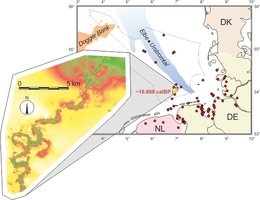
Buried valley of a postglacial river in the southern North Sea. This valley is a former tributary of the Elbe/Weser paleo-valley.


                                                                                                                                                                                                                                                                                                                                                                       Deciphering the formation history of shelf depositional and erosional elements provides a difficult to read, but sensitive record of environmental variability.

Loc­ally con­fined sed­i­ment de­po­cen­ters and erosional fea­tures in shelf sys­tems re­flect the vari­ab­il­ity of hy­dro­dynamic and cli­matic con­di­tions (Haneb­uth et al. 2011). Dis­lo­ca­tion and re-or­gan­isa­tion of such de­po­cen­ters (by sed­i­ment sup­ply, cur­rent-to­po­graphy in­ter­ac­tion, re­lo­ca­tion of trans­port path­ways, sea level) leads to a re­or­gan­iz­a­tion of the en­tire shelf sys­tem (Lantz­sch et al. 2010) in­clud­ing sed­i­ment­ary links from shelf to slope (Bender et al. 2012). Evol­u­tion of these ele­ments will be as­sessed by high-res­ol­u­tion seismo-acous­tic map­ping and ground-truth­ing (sed­i­mento­logy, geo­chem­istry) com­bined with nu­mer­ical sed­i­ment-trans­port mod­el­ing. We are cal­cu­lat­ing volumes and masses of sed­i­ment de­po­cen­ter suc­ces­sions and in­teg­rate them into a shelf-wide, LGM-to-present nu­mer­ical sed­i­ment-dis­tri­bu­tion model to un­ravel the dom­in­ant en­vir­on­mental forces and to ex­tract re­sponses within the shelf-slope sys­tem in a pro­gnostic way. Re­gions of in­terest are the shelves off SE South Amer­ica, Iberia, and the North Sea.  


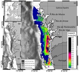
Volumetric budget calculation of sediment and carbon storage and export for a late Holocene mid-shelf mudbelt system (NW Iberia).


                                                                                                                                                                                                                                                                                                                                                                       Climate change controls the complex build-up of contouritic depositional systems by the interaction of different forces (e.g. sea level, ocean circulation, sediment input from land, etc.).

Con­tour­itic de­pos­itional sys­tems are gen­er­ated by long-last­ing con­tour-par­al­lel cur­rents whose strengths and bound­ar­ies are forced by vari­ations in cli­mate and sea level. Their ar­chi­tec­ture is also con­trolled by the in­ter­ac­tion of ocean cur­rents with local factors such as sed­i­ment sup­ply and bot­tom to­po­graphy, and by events such as abyssal storms (Re­besco and Cam­er­lenghi, 2008). The re­l­at­ive im­pacts of these forces on de­pos­itional geo­met­ries will be as­sessed. Ad­di­tion­ally, pro­cesses trig­ger­ing the sed­i­ment in­stabil­ity fre­quently ob­served within con­tour­itic de­pos­its will be in­vest­ig­ated. Fo­cus­ing on the cur­rent-dom­in­ated slope off Ar­gen­tina/Ur­uguay, seismo-acous­tic, sed­i­mento­lo­gical, geo­chem­ical, geo­tech­nical and trans­port/de­pos­itional mod­el­ing ap­proaches will be used to de­cipher the rel­ev­ant long- and short-term pro­cesses.  


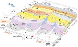
3-D Morpho-sedimentary map of the contouritic depositional system around the Mar del Plata Canyon (off Argentina).


                                                                                                                                                                                                                                                                                                                                                                       Sediment dynamics within submarine canyons are governed by climate-controlled down-slope transport processes and the interaction of along-slope transport and seafloor morphology.

Canyon sys­tems op­er­ate either as primary con­duits for sed­i­ments from the con­tin­ental mar­gin to the deep sea or as ma­jor sed­i­ment sinks. Sea-level changes con­trol the sed­i­ment de­liv­ery by chan­ging the shelf con­fig­ur­a­tion and by in­flu­en­cing the dy­nam­ics of bot­tom cur­rents, and there­fore their in­ter­ac­tion with the canyon to­po­graphy (Hen­rich et al. 2009). The type and volume of ma­ter­ial avail­able and the sed­i­ment trans­port mode are linked to the cli­matic re­gime. In par­tic­u­lar, vari­ations in the fre­quency and volume of tur­bid­ite suc­ces­sions will be ex­plored in the con­text of re­gional pa­leocean­o­graphic (con­tour-cur­rents) and pa­leo­cli­matic changes. We will ap­ply geo­phys­ical, geo­tech­nical, sed­i­mento­lo­gical (MeBo drilling) and geo­chem­ical meth­ods to the study of canyon sys­tems off SE South Amer­ica and NW Africa.  


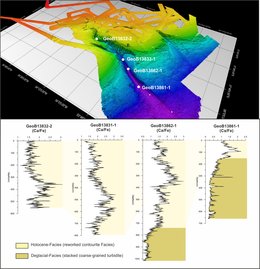
Map of the Mar del Plata Canyon with locations of studied cores (top) and the distribution of reworked contouritic facies and coarse-grained turbiditic facies in the cores (bottom). 


Nach oben