
Carbon Capture & Storage (CCS) - Hydrogen Storage
The global CO2 emissions of mankind is posing an extreme risk for the earth, its habilitity and its climatic stability. While savings of CO2 is one path to go to fight climate change, another option would be the extraction of CO2 from natural systems, namely the atmosphere, and to store it in the underground. Various possibilities are currently explored.
While this topic is subject of various research initiatives, also in geosciences, MTU became involved through a cooperation with BGR, where a possible storage structure was to be surveyed in the German North Sea, and complimentary high-resolution seismic data were planned to be acquired.
A very different approach to capture CO2 is a storage considered in oceanic crust. The basic idea is a conversion into carbonate minerals through precipitation, and the Cascadia Basin has been considered as a test bed. We will contribute with seismic data to further plans of an injection experiment.
Sedimentary Basins
As part of the transition to renewable energies, the storage of gas in the deeper underground, either CO2 for carbon sequestration (CCS) or hydrogen in the vicinity of windfarms, when excess power is produced (Power2Gas), is a growing demand. Offshore Germany, particularly the sedimentary setting in the North Sea may provide suitable formations combined with effective seals. Since a major element in the structural framwork is the presence and tectonic activity of Zechstein Salt, details of possible storage formations as well as barriers/seals need to be studied at a sufficiently high level of detail.
Gas migration in tne North Sea is a well-known and well-studied phenomenon e.g. from the Dutch or UK sector, where hydrocarbon exploration and production has been ongoing for decades. It might also pose a risk, if migration is trapped at very shallow depth of a few tens of meters beneath the seafloor in the reach of windfarm foundation. As an example study, an area in the Western German North Sea (Entenschnabel) has been selected for a 3D seismic survey to be carried out as part of the MSM100 expedition with R/V Maria S. Merian using the BGR high-resolution multichannel seismic system (up to 250 Hz) and 2 streamers of x km length with group length of 12.5 meters.
It was intended to image not only the potential reservoir at 1-2 km depth, where Cenozoic shales serve as possible seal, but also the deformation of the shallower sediment column by faulting at salt diapirs, associated subsidence and the relation to possible triggering by glacial loading. The area had already been surveyed commercially during hydrocarbon exploration, but at much lower resolution than needed for the evaluation of seal quality and imaging of fluid/gas migration pathways. The expedition is part of the Project GeoBasis-3D, lead by Dr. Axel Ehrhardt at BGR with partners at Bremen University (H. Keil, S. Wenau) and University of Hamburg (C. Hübscher, D. Gajewski). The shiptime proposal included a MTU participation with our 2D multichannel seismic equipment to complement the work with a higher-resolution imaging of the shallow subsurface. However, in the late planning phase this part had to be postponed due to logistical contraints during operation on the ship.
Currently, we are carrying out a comparison between BGR and MTU seismic data to judge the imaging advantages and deficits and define the need for high-resolution studies in case of a potential storage plan.
North Sea
 Oceanic Crust
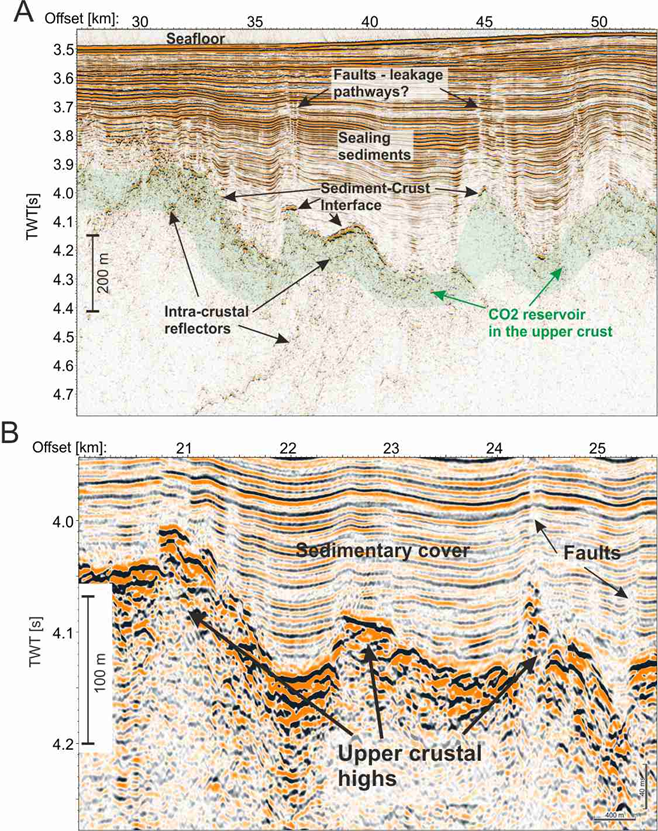
 The sequestration of CO2 was also considered within deep sea basalt aquifers in ocean crust. In contrast to classical reservoirs, where CO2 might reside in fluid state and might remain mobile, here CO2 is converted into chemically stable and non-toxic minerals. While this has never been yet implemented in a technical approach, MTU has participated in 2018 in a funding proposal 11 international partners from US, Norway, France, UK, Iceland and Germany to the ERA-NET funding program ACT (Accelerating CCS Technologies). The main purpose was to provide a computational analysis of multiphase flow and trapping processes that are consistent with pore-scale fluid dynamics and geochemistry of basalt reservoirs to better forecast, quantify, and optimize storage efficiency. As possible pilot studies the Cascadia Basin was selected besides the Norwegian Continental Shelf (NCS) and New Caledonia. The project was designed to expand existing datasets for pore-scale geochemistry, providing a framework for reservoir characterization for oceanic crust, quantifying and optimizing storage capacities through modeling, and, finally, informing decisionmaking and providing advancement for CCS technologies. Our contiribution to the CAROMBA Project (CAROMBA - CARbon dioxide Offshore storage and Mineralization in BAsalt) would have been the seismic characterization by reprocessing our year 1996 and 2000 data.
 While the ACT project, which German part CAROMBA-SEIS was submitted to PTJ funding, had not been successful, we are currently evaluating our seismic data from the Cascadia Basin in the framework of a master thesis. The seismic imaging of basaltic reservoirs is particularly chellenging because of the roughness of the lava flows, and thereby the evaluation of continuity and connectivity is not easy. Beyond this, the disruption of aquifer by faulting is clearly present to crustal ages of several million years, and thus needs to be mapped to determine the spatial extent of a promising reservoir.
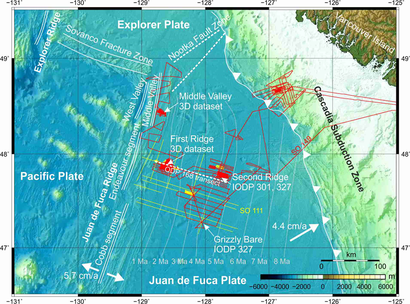
In cooperation with a group of colleagues from the US and Canada, a preliminary proposal had been submitted to IODP for a drilling campaign in the Cascadia Basin, which targets a pumping experiment of CO2 into the ocean crust, which had been previously investigated for crustal hydrology on drilling expeditions ODP 168, IODP 301, 321T and 327. For this purpose, we intend to evaluate our high-reolution multichannel seismic data acquired during Cruises SO111 and SO149 for the reservoir characterization in the vicinity of the original IODP drill sites.
Cascadia Basin Reference Data