
Research Highlights
2003:
Shallow Water MCS
In 2003, the working group MTU introduced the first single hydrophone streamer worldwide for academic work. The purpose was to overcome deficits, which all commercial streamers revealed because of the directivity due to extended groups of several hydrophones, which distorts recording of waves at high reflection angles.
since 2003: Sustainability & Renewable Energy
Geophysical investigations are key for soil characterization, but in shallow water, appropriate technologies, approaches and data processing schemes were not available. Therefore we have initiated in 2003 a workshop with windfarm developers, engineers and goverment institutions to promote quality measures and improve the use of seismic data for quantitative soil investigations. Since then, we have strongly improved academic efforts and supported since 2010 also the built-up of a geophysical group at Fraunhofer IWES, which directly cooperating with windfarm industry. This lead to a strong group of >25 professionals, leading windfarm survey work in Europe.
Jointly, we have been successfully applying for 4 different applied research projects funded by Ministry of Economy.
1993: Digital Echosounder Data
Since 1989, V. Spiess developed the worldwide first digital data acquisition system for echosounder data up to 50 kHz frequency. Until this time, only analog recordings in black&white on thermal paper were available for scientific work. Since then, echosounder data could be processed using all kinds of seismic data processing methods, data could be properly scaled and displayed in color on screen, paper and in image files.
The ParaDigMA system was subsequently installed on all large German research vessels, Sonne, Meteor, Polarstern. Lateron, the ParaDigMA software technology was incorporated into the commercial ParaStore Acquisition software, which was delivered with the new generation of Parasound Parametric Sediment Echosounder Systems by Atlas Hydrographics.
It could be shown that decimeter-scale acoustic data can be matched with core logging data on sediments from gravity and piston as well as (I)ODP drill core data including synthetic seismograms. But high quality of physical property measurements are essential then.
Spiess (1993)
2020: Statistical Stratigraphy for Seismic-Core Integration - Bengal Fan Drilling Transect

Sedimentary fans are constructed by channel-levee units (CLS), representing very high accumulation, and interlevee hemipelagic and sandy units. Developing a stratigraphy is particularly challenging since deposition is restricted to lateral bands near active channels. Since those are switching over time due to avulsion, the development of a consistent stratigraphy is not possible from just seismic interpreation.
With the results of IODP drilling expedition 354 to the Bengal Fan, constraints become available from various dating methods such as 14C of wood and foraminifera, microfossil stratigraphy, litho-, cyclo- and magnetostratigraphy. A new age-modeling approach from Reilly was applied to the seismic stratigraphy of Bergmann, providing the spatial and temporal succession of CLS.
As a result we could provide a complete, most probable age model for a 320 km long transect across a fan desipite the lack of any continuous age record at any single drilling location.
Bergmann et al. (2019), Reilly et al. (2020)
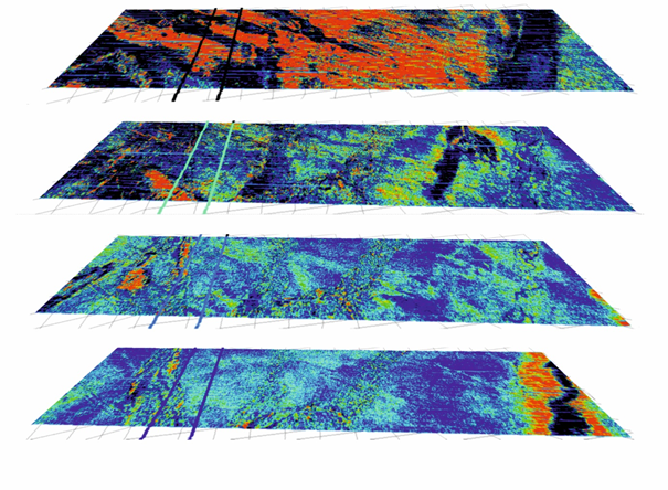
2018: Boulder Detection
 In the Northern hemisphere glaciers have transported large quantities of rocks and boulders, which remain in the landscape and concentrate in moraines and depressions. In the Baltic Sea and on Northern hemisphere continental shelves they pose a potential risk for offshore constructions.
In our project 'Boulder Detection', funded by the Ministry of Economy, we have developed a method to locate boulders in the subsurface using a profiling methods which is operating similar to a multibeam approach. Reflections and diffractions can be separated and located. The patented method is now jointly used with Fraunhofer IWES in commercial applications, and basic results have been recently published from a master thesis.
Stange et al. (2022)
since 2004: High-Resolution 3D Seismic Surveying
 High-resolution seismic acquisition requires an adaption of technology such as streamers and seismic sources to the demands for high-quality imaging. The 600 m long 96-channel streamer, which could be purchased in 1994, was specially designed with programmable group lengths between 0.5 and 6.25 meters, so that also high frequencies above 500 Hz as from a watergrun or micro GI Gun could be properly recorded without directivity issues.
Using this equipment, since then we have carried out more than 100 expeditions, but also several single-streamer threedimensional seismic surveys to image details of the shallow sub-seafloor within the upper few hundred meters of sediment. The regions were Cascadia Margin, Cascadia Basin (2x), Costa Rica, Black Sea (2x), Congo, Bengal Fan, Liguria and Gulf of Naples (2x).
Recently, in cooperation with Fraunhofer IWES, a new true 3D seismic system with 4 short parallel streamers could be used in the Baltic Sea and North Sea.
e.g. Steinmann et al. (2018), Wenau et al. (2017), Zühlsdorff & Spiess (2004, 2006)
2004: Natural Hydraulic Fracturing
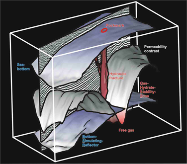 Pockmark formation was traditionally related to overpressured gas reservoirs. Offshore Vancouver Island, the accretion of thick sediments leads to folding and formation of anticlines, which act as traps for migrating biogenic gases. Compressional faults would then align parallel to the ridge crests.
Surprisingly, at Bullseye Vent, the zone of intense gas seepage is narrow and elongated, but other than expected oriented perpendicular to the crest. Thus it does not follow any compressional fault as zone of weakness. Instead we had proposed that natural hydraulic fracturing has created such zone. That implies that the fracture was created by water-driven overpressure, which would then form parallel to the main stress direction. Main differences is the limited spatial extent of the fracture compared to a fault plane, and the durationof fracture development, which would be an event for gas overpressure and release, while water overpressure can be maintained over much longer times. Percolation of gas may work in dissolved form until the solubility drop releases free gas bubbles near the seafloor.
A similar phenomenon has been observed in the Congo Fan at the Regab Pockmark, where salt rafting causes downslope compressional forces.
Zühlsdorff & Spiess (2004), Wenau & Spiess (2018)
2018: The Largest Coldwater
Coral Mound Field off Argentina
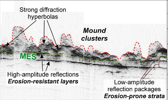 During R/V Sonne Cruise SO260 in 2018, the contourite depositional system off Argentina and Uruguay was investigated. Compared to previous cruises, higher resolution imaging with multibeam, echosunder and seismics could reveal areas, where in combination with distinct erosion also a pronounced roughness was observed, which originates from a dense
  distribution of features of a few to >30 meters height. Sampling confirmed deep water coral mounds.
More than 2000 km2 or more are presumably covered with cold water coral mounds, but also buried mounds have been found in deeper water, which documents a major change in the oceanographic setting through geologic time.
Steinmann et al. (2020)
2013: Earthquake Induced Gas Flow
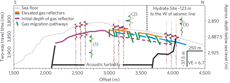 At the deformation front of the Makran Accretionary Prism, rapid shortening and folding leads to an uplift, which promotes gas migration, gas hydrate formation, but also focused transport to the seafloor.
Near a coring site, seismic data reveal acoustic turbidity and a shallow gas front capped by gas hydrates, but nearby this zone is distorted and shallow high amplitude patches. Geochemical data indicate that a recent event has also disturbed the diffusion gradients, and modeling allowed to link it to a 1945 earthquake at Nascent Ridge.
Fischer et al. (2013)
2006: Forced Folding and Seismic Amplitudes
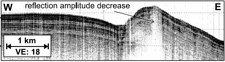 Oceanic plates are characterized by vigorous hydrothermal circulation, which is cooling the lithosphere early after the emplacement of the plate material. High permeability of the surficial basaltic layer also allows lateral flow. If sediment covers the crust after a few million years, exchange with the ocean is inhibited and conductive cooling prevails. In the course of our research in the Cascadia Basin, which was complimentary to (I)ODP drilling initiatives on oceanic
 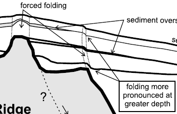 hydrology, we identified narrow anomalies in seismic and acoustic amplitudes within the sediment cover, which resembled gas driven pathways known from hydrocarbon provinces.
Since gas cannot explain these features due to the low organic matter content of the sediments, the mechanism of forced folding was proposed. This occurs due to differential compaction between the thin cover above basement ridges and thicker sediment nearby. At critical knickpoints and highs, layers are stretched over geologic time, which in turn changes physical properties and reduces impedance contrasts.
Zühlsdorff & Spiess (2006)