2018 07 - VWFS WEGA Cruise 173
 Seismo-acoustic Imaging in and around the Wind Farm Clusters Nr. 7, Nr. 3, and in the Eastern German North Sea
24.07.-02.08.2018 - North Sea : Bremerhaven - Helgoland - Bremerhaven
Chief scientist: Dr. Benedikt Weiß (BSH)
Chief Seismic: Dr. Fekete
MTU Participants: Stange, Schulze, Sierra, Warnke
Vessel Overview and Fact Sheets at BSH
Instrumentation:
- Sodera micro GI (Generator-Injector) Gun 2 x 0.1 L
- DuraSpark 400 (Fraunhofer IWES)
- Applied Acoustics single-channel streamer (BSH)
- Teledyne Streamer 220 m, 96 channels, single hydrophone groups
- Innomar SES 2000 (BSH)
 The German North Sea has been a location of extensive offshore wind farm construction for the last two decades. Turbine fields and individual sites need high-quality geophysical-geotechnical assessment down to 100 m sub-seafloor in order to ensure suitable foundation properties, to allow for the safety and stability of equipment. However, the survey efforts are normally limited to single fields due to economic reasons. BSH, in cooperation with the University of Bremen, has set out to acquire a geological overview to sub-construction depths in order to allow a unified geological interpretation of different wind farm clusters, to set a standard for necessary pre-construction surveys, and to widen the understanding of North Sea evolution during the last three ice ages. To tackle these tasks, a series of cruises in an approximately annual rhythm are planned, during which various seismo-acoustic measurements will be carried out. The first one in the sequence was expedition Wega173, where an analogous multichannel surface streamer, a single-channel surface streamer, a micro GI air pulser, and a Dura sparker were utilized, together with an Innomar SES installed in the ship's moon pool.
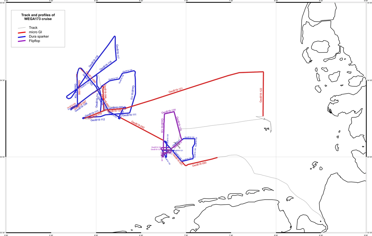
The main target of the cruise was seismo-acoustic work in the area N-3, as well as N-7 and its vicinity in the northwestern segment of the German North Sea, beside hydrographic measurements carried out by the BSH in area N-3 after the port call on Helgoland. A long overview line connecting the western border to the prominent bathymetric step offshore Dithmarschen was also acquired.
The cruise was short but successful and in spite of challenging weather conditions concluded with short of 500 nautical miles of high-quality seismo-acoustic data.