
2010 07 - MSM16-1 Baltic Gas
 MSM 16-1b - 31.07. -22.08.2010 - Baltic Sea: Warnemünde - Visby - Emden
Working Areas in Baltic Sea: Mecklenburg Bay, Arkona Basin, Bothnian Bay, Bothnian Sea, Gotland Basin, Bornholm Basin
 This cruise was part of the EU-funded project BONUS Baltic Gas
Partners
- Institute for Baltic Sea Research, Warnemünde (IOW)
- Department of Geosciences, University of Bremen, Bremen (GeoB)
- Max Planck Institute for Marine Microbiology, Bremen (MPI)
- Alfred Wegener Institute for Polar and Marine Researach, Bremerhaven (AWI)
- Geological Survey of Denmark, Copenhagen (GEUS)
- National Environmental Research Institute, Aarhus
- Center for Microbiology, University of Aarhus (CfG)
- Geological Survey of Finland (GTK)
- Department of Geology, Lund University,
- Department of Geological Sciences, University of Stockholm
 Seismic Instrumentation
- micro GI Gun 2 x 0.1 L (Generator-Injector; Sodera)
- Arstech Streamer 50 m 48 channels (single hydrophones)
- Syntron Streamer xxx m nn channels (short group spacing)
- MaMuCS Recording System
MTU Participants:
- Spiess, Volkhard
- Keil, Hanno
- Fekete, Noemi
- Toth, Zsuzsanna
General Cruise Plan
Long and short piston coring will be performed in various regions of the Baltic Sea in connection with the key questions of the different programs, with special emphasis on areas of shallow gas accumulation. Detailed geochemical and geophysical analyses will allow to
- estimate the diffusive fluxes of methane (DIC, DOC)
- Identify biogeochemical key parameters and microbial process rates and community structures affecting the methane turnover in Baltic Sea sediments
- derive information on the history of the redox state and the history of anoxia
- derive information on the development of salinity from biological and chemical proxies to reconstruct the saltwater inflow history of the Baltic Sea
Geophysical, hydrographical, and geochemical investigation of gas seep sites in key areas of the Baltic will be executed to understand the structural characteristics as well as the quantity and fate of the gas in the water column and its potential emission into the atmosphere. This will be followed by means of acoustic methods to reveal the subsurface structure and measure frequency-dependent seismoacoustic amplitudes, high resolution swath bathymetry and backscatter mapping of the seafloor, multi- and single beam methods for flare-imaging, detailed water column methane inventory sampling using IOW’s pumped CTD system and current data, turnover rates of oxidation in the water column, shore-based stable carbon isotope analysis, and surface water equilibration methods to assess the resulting air-sea flux of methane on site. Multi-system acoustic imagery of gas-rich sediments have to establish reference areas for acoustic instrumentation, with the goal
- to derive gas bubble size distributions in the sediments from the response to various frequencies
- to have an accurate data base to develop new algorithms for sedimentary gas quantification from seismoacoustic data
- to correlate shallow gas findings with wide-angle multibeam backscatter data for spatial extrapolations
Working regions for this cruise include the Bornholm Basin, the southern and northern Gotland Deep, the Bothnian Sea, and the Bothnian Bay (Fig.2). Long piston core transects will be retrieved in all major basins, covering sediments with or without shallow gas presence, the latter unambiguously needed for reference. Wherever possible, transects from gas-underlain to coarser sediments will be sampled, the latter using a vibrocorer. Water column sampling for methane and its stable isotopes will reveal whether the different sedimentary methane load is mirrored in the local bottom water
methane concentrations.
Single stations will be dedicated to questions related to the projects INFLOW and HYPER. Due to the large amount of parameters investigated, we plan to take two cores at most of the sites. A total of 24 stations is anticipated. Detailed positions of stations will depend on results of data mining and
the results of RV Poseidon Cruise 392.

 Seismic Activities
Seismic work was spread over the different basins for mostly short surveys, except for Gotland and Bornholm Basin, which Parasound sediment echsounder data were acquired almost during the whole cruise. They were equally important for gas quantification, as it delivers 3 different frequencies between 4 and 40 kHz. Together with the airgun seismic data, a wide range of frequencies is availalbe to study for example frequency-dependant phenomena such as attenuation, which is depenadant on the gas concentration and bubble size. The availability of multiple frequencies also ensures that the gas layer can be penetrated at the optimum resolution, so that sediment nature and thickness can be determined.
Seismic equipment was tested after departure from visby to acquire Line GeoB10-017 near Gotland. Subsequently, the northernmost Baltic Sea was surveyed.
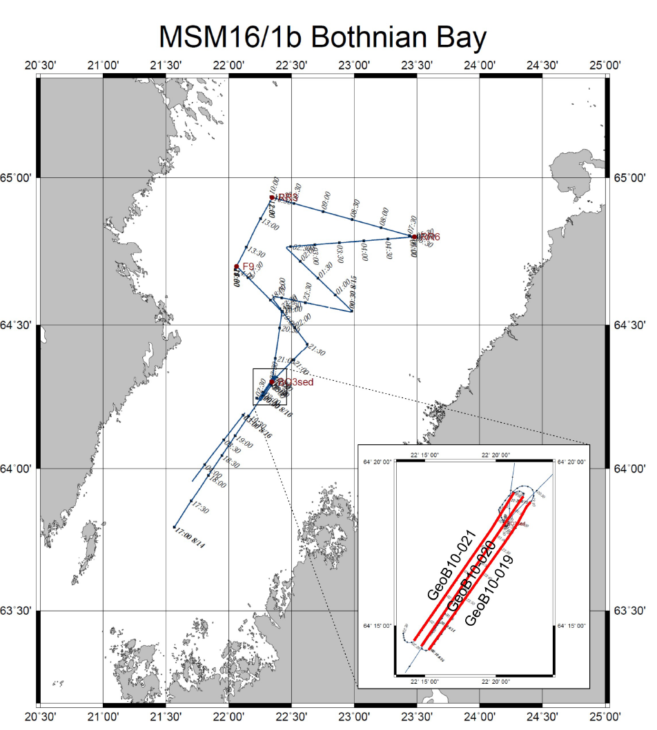
Bothnian Bay / Bothnian Sea
In the northermost part of the Baltic Sea, a small MCS together with extended Parasound measurements were carried out. A single longer line was shot in the Bothnian Sea (Line GeoB10-018) with bot a short and a longer streamer. Basically, Parasound data penetrate most of the sediments of interest for the Baltic Gas project, i.e. the Holocene and late glacial deposits.
In the Bothnian Bay, three narrow lines were shot in its deepest part (Lines GeoB10-019 through -021), but no indications for shallow gas were found. Otherwise, a more extended grid of Parasound lines was acquired.


Gulf of Riga
On the return from the North and after a successful extension of the research permission to work with seismic systems in the Gulf of Riga (Latvia), we acquired 4 seismic lines in the deepest part of the Gotland Basin. There, high sediment thickness was known, but the base of the sediment infill was mostly blanked by gas layers in the shallow subsurface.
The MCS data confirmed that sediment thickness may exceed 70 meters in some locations.
Bornholm Basin
The key area for the GeoB seismic survey work was the Bornholm Basin, where a lot of additional information was already available. Here we intended to carry out a quantification study based on seismic parameters such as attenuation, interval velocity and Amplitude-versus-Angle/Offset (AVA/AVO).
4 lines (Lines GeoB10-026 through -029) were shot in the northern part of the study area to combine with Parasound as well as multibeam data.
The remaining grid (Lines GeoB10-030 through -046) provided an overview of the gas distribution in the Bornholm Basin, in particular to determine the base of the Holocene sediments. Since thickness could not be determined with echosounder data, but controls the amount of organic matter, the seismic data basically provided a rough map of the bedrock or top of glacial till. This could be used for further modeling studies on organic matter degradation the methane production rates.