
2021 05 - R/V Maria S. Merian Cruise MSM100 - GeoBaSIS-3D
 Geophysical Investigations for Barrier Structures and their Integrity
in the subsurface of the German North Sea by means of 3D-Seismic data
12.05.–09.06.2021 : Emden - Emden
Chief Scientist: Dr. Axel Ehrhardt (BGR)
Co-PIs: Dr. Hanno Keil, Dr. Stefan Wenau, Dr. Christian Hübscher, Dr. Dirk Gajewski
MTU Participants: Albers, Meyer
Groups involved
- Bundesanstalt für Geowissenschaften und Rohstoffe, Hannover (BGR)
- Working Group Marine Technology/Environmental Research, Department of Geoscience, Bremen University (GeoB AG Spiess (MTU))
- Institute for Geophysics, University of Hamburg
Instrumentation:
- Parasound
- Multibeam
 As part of the transition to renewable energies, the storage of gas in the deeper underground, either CO2 for carbon sequestration (CCS) or hydrogen in the vicinity of windfarms, when excess power is produced (Power2Gas), is a growing demand.
Offshore Germany, particularly the sedimentary setting in the North Sea may provide suitable formations combined with effective seals. Since a major element in the structural framwork is the presence and tectonic activity of Zechstein Salt, details of possible storage formations as well as barriers/seals need to be studied at a sufficiently high level of detail.
Gas migration in tne North Sea is a well-known and well-studied phenomenon e.g. from the Dutch or UK sector, where hydrocarbon exploration and production has been ongoing for decades. It might also pose a risk, if migration is trapped at very shallow depth of a few tens of meters beneath the seafloor in the reach of windfarm foundation.
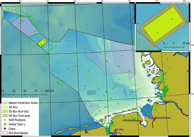
As an example study, an area in the Western German North Sea (Entenschnabel) has been selected for a 3D seismic survey to be carried out as part of the MSM100 expedition with R/V Maria S. Merian using the BGR high-resolution multichannel seismic system (up to 250 Hz) and 2 streamers of x km length with group length of 12.5 meters.
It was intended to image not only the potential reservoir at 1-2 km depth, where Cenozoic shales serve as possible seal, but also the deformation of the shallower sediment column by faulting at salt diapirs, associated subsidence and the relation to possible triggering by glacial loading. The area had already been surveyed commercially during hydrocarbon exploration, but at much lower resolution than needed for the evaluation of seal quality and imaging of fluid/gas migration pathways.
The expedition is part of the Project GeoBasis-3D, lead by Dr. Axel Ehrhardt at BGR with partners at Bremen University (H. Keil, S. Wenau) and University of Hamburg (C. Hübscher, D. Gajewski).
The shiptime proposal included a MTU participation with our 2D multichannel seismic equipment to complement the work with a higher-resolution imaging of the shallow subsurface. However, in the late planning phase this part had to be postponed due to logistical contraints during operation on the ship.
It is intended to carry out a high-resolution seismic survey on a separate cruise after the first analyses of the low-resolution seismic data.
 Existing MTU Line He569-GeoB21-002 in the vicinity of the 3D survey area of GeoBaSIS-3D and data example (0.75 sec TWT), revealing a tunnel valley and the uplifted sediment column due to salt diapirism including deeper gas traps.

Cooperation
In the course of the cooperation with BGR, we will focus on the processing of multibeam and sediment echosounder data.
In addition a master thesis will be carried out from spring 2022 to evaluate the BGR seismic data regarding shallow imaging quality. These data will be compared to existing MTU data to further plan the high-reolution 3D survey.