
2000 08 - R/V Sonne Cruise SO149
16.08.-16.09.2000 - Cascadia Basin/Margin (Canada) - Victoria - Victoria - Victoria
Working Area: Cascadia Basin, Cascadia Margin
Chief Scientist: Prof. Dr. Spiess
MTU Participants: Zühlsdorff, Schwenk, Bartels, von Larcher, Meffert, Boeke, Matschkowski
Cruise Report, Weekly Reports, Detail Maps
Groups involved
- Working Group Marine Technology/Sensors, Department of Geoscience, Bremen University (GeoB, AG Villinger)
- Working Group Marine Technology/Environmental Research, Department of Geoscience, Bremen University (GeoB AG Spiess (MTU))
- University of Victoria, BC, Canada
Instrumentation
- GI Gun 2 x 0.4 L + GI Gun 2 x 1.7 L (Generator-Injector; Sodera)
- 2 x Watergun S-15 0.16 L (Sodera)
- Syntron Streamer 600 m, 96 channels, 6.25 m groups or less, including single hydrophones with preamp
- Bison Spectra Recording System 48 channel, 20 kHz
- Bison Jupiter Recording System 48 channel, 4 kHz
- Multibeam System Hydrosweep DS 15.5 kHz - Atlas Elektronik
- Parasound Sediment Echosounder 18/4 kHz - Atlas Elektronik
- ParaDigMA Digital Acquisition for Parasound
- Heat Flow Probe (AG Villinger)
R/V Sonne Cruise SO 149 was jointly carried out with colleagues from AG Villinger.
The hydrologic character of the earth's crust plays an important role in a number of geological and geophysical processes, which occur in a variety of geological settings as oceanic spreading centers, flanks of oceanic ridges, and outcrops of high permeable basement through layers of low permeable sediment. Large-scale hydrothermal circulation, which is most pronounced in the vicinity of submarine volcanic ridges but may still carry on within the crust for several millions of years, significantly affects the heat flow as well as the global geochemical cycles of both lithosphere and oceans [e.g. Lowell etal., 1995].
Seismic data can contribute to the investigation of fluid flow if flow-related processes affect structure or physical properties of the sediments. Since both seismic velocity and bulk density of marine sediments strongly depend on porosity, porosity anomalies are often associated with velocity anomalies or variations in seismic reflection amplitude, indicating compaction driven fluid expulsion [Bray and Karig, 1985; Minshull and White, 1989], elevated fluid pressures [e.g. Waldner and Nur, 1984], or the presence of permeable pathways [Zuhlsdorff et al, 1999]. Seismic data can also be used to identify other potential fluid conduits like faults [e.g. Zuhlsdorff et al., 2000]. However, to image flow-related features and to estimate the spatial extend of potential upflow zones and the volumes of sediment and pore space that host the flow, the quality and resolution of seismic data, which both depend on the source frequency range, have to be sufficiently high.
 One of the characteristics of seismic data is that signal penetration decreases if higher source frequencies are used to image sediment structures in greater detail. Furthermore, seismic data are often deteriorated by other frequency dependent effects like scattering or interference. These difficulties can be overcome if a multi-frequency data set is acquired, which provides maximum temporal resolution at different depth levels and is sufficient to investigate a possible frequency dependence of seismic features.
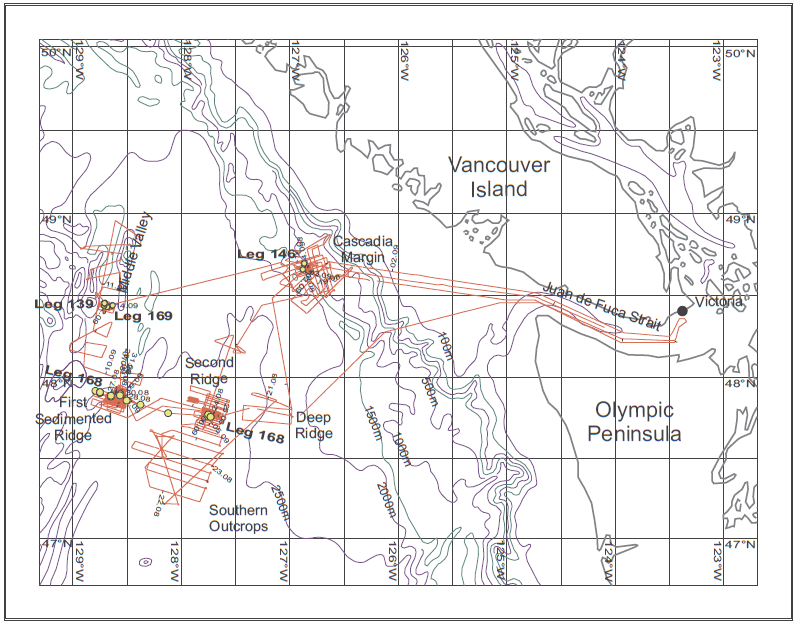
To meet these requirements, all components of the multi-channel seismic system of the University of Bremen, including seismic sources, streamer, and the data acquisition unit, were designed to optimize lateral and vertical resolution. Furthermore, the system allows to operate different seismic sources in an alternating mode. The seismic records are further combined with hydroacoustic data as provided by the narrow beam Parasound echosounder and the Hydrosweep multibeam swath sounder, which maps the seafloor bathymetry. Since seismic and hydroacoustic systems can be operated simultaneously due to the different source frequency ranges, required ship time is minimized and the accuracy of navigation is improved. Thus, a unique, high resolution multi-frequency data set is provided. The system was first employed and tested during R/V Sonne Cruise SO 111, which was carried out in late summer 1996 [Villinger et al., 1996]. R/V Sonne Cruise SO 149 was now intended to build on the success of Cruise SO 111 and to study different types of fluid flow at the eastern flank of the Juan de Fuca Ridge (First Ridge area), at a part of the active ridge system (Middle Valley area), and in the deep Cascadia Basin (Second Ridge, Southern Outcrops, and Deep Ridge areas), focussing on high resolution multi-frequency seismics complemented by measurements of heat flow and electric resistivity. The main objective was the 3D imaging of potential fluid pathways and local tectonic structures at high source frequencies, especially in the vicinity of the Ocean Drilling Program (ODP) Leg 139, 168, and 169 sites, as well as the preparation of new international projects under the umbrella of the ODP and the proposed seafloor fiber-optic network (NEPTUNE). Cruise SO 149 was carried out in very close cooperation with the international shipboard scientific party of the American R/V Thomas Thompson, which started one week later focussing on geological and geochemical sampling as well as more heatflow measurements on some of the seismic lines measured during SO 149.
Cascadia Basin - SO149
Zühlsdorff, L., and V. Spiess (2006), Sedimentation patterns, folding, and fluid upflow above a buried basement ridge: Results from 2-D and 3-D seismic surveys at the eastern Juan de Fuca Ridge flank, J. Geophys. Res., 111, B08103, doi:10.1029/2004JB003227.
Hutnak, M., A. T. Fisher, L. Zühlsdorff, V. Spiess, P. H. Stauffer, and C. W. Gable (2006), Hydrothermal recharge and discharge guided by basement outcrops on 0.7–3.6 Ma seafloor east of the Juan de Fuca Ridge: Observations and numerical models, Geochem. Geophys. Geosyst., 7, Q07O02, doi:10.1029/2006GC001242.
Zühlsdorff, L., M. Hutnak, A. T. Fisher, V. Spiess, E. E. Davis, M. Nedimovic, S. Carbotte, H. Villinger & K. Becker (2005) Site surveys prior to IODP Expedition 301: ImageFlux (SO 149) and RetroFlux (TN116) expeditions and earlier studies. IODP Leg 301 Initial Reports. doi:10.2204/iodp.proc.301.102.2005.
GA Spinelli, L Zühlsdorff, AT Fisher, CG Wheat, M Mottl, V Spiess, ... (2004) Hydrothermal seepage patterns above a buried basement ridge, eastern flank of the Juan de Fuca Ridge (DOI 10.1029/2003JB002476). Journal of Geophysical Research-Part B-Solid Earth 109 (1)
Fisher, A. T., E. E. Davis, M. Hutnak, V. Spiess, L. Zühlsdorff, A. Cherkaoui, L. Christiansen, K. Edwards, R. MacDonald, H. Villinger, M. J. Mottl, C. G. Wheat & K. Becker (2003) Hydrothermal recharge and discharge across 50 km guided by seamounts on a young ridge flank, Nature, 421, 618-621.
Cascadia Basin - SO111
Zühlsdorff, L., Spiess V. (2001) Modeling seismic reflection patterns from Ocean Drilling Program Leg 168 core density logs: Insight into lateral variations in physical properties and sediment input at the eastern flank of the Juan de Fuca Ridge. J. Geophys. Res., 106, 16119-16133.
Zühlsdorff, L., V. Spiess, C. Hübscher, and M. Breitzke (1999) Seismic reflectivity anomalies in sediments at the eastern flank of the Juan de Fuca Ridge - evidence for fluid migration. J. Geophys. Res., 104, 15351-15364.
Cascadia Margin - SO149
Zühlsdorff L and V. Spiess (2004) Three-dimensional seismic characterization of a venting sites reveals compelling indications of natural hydraulic fracturing, Geology, 32: 101-104.
Cascadia Margin - SO111
Zühlsdorff, L., V. Spiess, C. Hübscher, H. Villinger, and A. Rosenberger (2000) Implications for focused fluid transport at the northern Cascadia accretionary prism from a correlation between BSR occurrence and near-sea-floor reflectivity anomalies imaged in a multi-frequency seismic data set, Int. J. Earth Sci., 88, 655-667.