
2016 05 - R/V Heincke Cruise He463 - PalaeoDogger
 Postglacial drainage systems in the northern German Bight
11. 05 – 27.05.2016 : Bremerhaven – Bremerhaven
Chief Scientist: Dr. Hanno Keil
MTU Participants: Oguro, Brune, Pavlak, Ehmen
In the course of the environmental reorganization of the North Sea shelf since the Last Glacial Maximum, the Elbe-Palaeovalley (EPV) changed its hydrogeological character from a glacial meltwater drainage system along the Scandinavian ice sheet (SIS) margin into a sea inlet with various major and regional tributaries, before the EPV finally got drowned in the modern 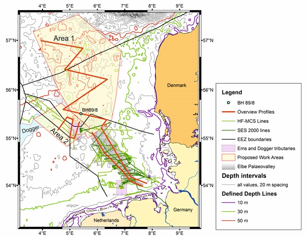 North Sea during the post-glacial transgression. One target of this proposal is to understand the hydrogeological role and evolution of a recently discovered tributary system of the EPV, which drained the exposed Dogger Bank area. Based on findings from RV Heincke cruise HE405 (2013) focusing on the infill history of the southern EPV in the course of the transgression, a second target is to investigate the partially speculative pathway of the northern EPV and the underlying morphology. A third target is to understand the infill pattern related to large scale circulation and palaeo-topographic constrains. For all targets we will obtain data with seismic surveys and vibrocoring in Danish, Norwegian, German and Dutch waters. The results will provide new insights in the EPV as a regional dewatering system since the late Weichselian and increase our understanding about the role of tributary systems in forming the Mesolithic Doggerland landscape in the present-day North Sea.
Location of the study areas in respect to the known position of the Elbe-Palaeovalley and the Dogger Bank. Magenta rectangles show the position of the Dogger drainage channel (north) and the Palaeo Ems (south). Existing MCS and SES lines in the German Bight are also shown. The red overview lines shall provide a first base for the exact location of a denser survey line network.
Groups involved:
- Department of Earth Science, University of Bergen, Norway (Prof. Haflidi Haflidason)
- Department of Geosciences and Natural Resource Management, University of Copenhagen, Denmark
Equipment:
- Highfrequency shallow water multichannel seismics
- Single channel seismic Boomer
- Echosounding systems
- Vibrocorer
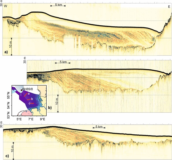
SES 2000 parametric subbottom profiler lines crossing the Elbe-Palaeovalley at three different latitudes as indicated in the inset. The images show a color coded display of the envelope of the recorded signal. The depth scale has been calculated assuming a sound velocity of 1500 m/s.
Fluvial system southeastern of the Dogger Bank: (A) Seismic visualization of the earliest Holocene palaeosurface and valley basis showing a complex fluvial system. (B) Interpretation of the seismic grid showing rivers, oxbows and bogland.
Paleo-Ems: (A) Assured river course of the hidden Palaeo-Ems and the modern Ems River in relation to the Elbe-Palaeovalley. The hypothetical course (dashed red line), connecting the present-day Ems estuary and the mapped palaeo fluvial system. (B) Map of the Holocene base outlining the river valley as mapped from seismic data.