
D4
D4 - Constructional impacts on bedform dynamics
Benjamin Schlue, Hanno Keil, Tilmann Schwenk
The aim of this project is the geophysical and geotechnical seabed characterization, with a special focus on assigned offshore construction sites (e.g. wind energy parks), the correlation of survey information with soil strength data, and the study of local offshore structure-seabed interactions in a morphodynamic and micromechanical sense. A new shallow-water multichannel seismic system will be used to derive volume and reflector seismic properties, which can be compared with in-situ geotechnical measurements and samples to generate statistically significant correlations between geotechnical and geophysical data as predictive tools for sedimentary site characterization. New-pipe laying techniques in non-cohesive substrates will be evaluated, designed and tested. The project specifically addresses how upcoming offshore foundation activities may affect the dynamic strength of the Pleistocene and Holocene sediment. Within the framework of research area D, this project deals with an accurate site characterization by surveys, sampling and in-situ measurements, while the complimentary project D1 focuses on the environmental impact of harbors and constructions. Beyond the scientific and methodological challenges in shallow water research, the proposed project intends to provide relevant methods and data for future tasks in marine offshore construction work, to keep close contact with administration units (e.g. BSH, BGR) and survey (e.g. OSAE) and construction companies, and to build up expertise for student education in applied geosciences.
Multifrequency Seismoacoustic Survey of a planned Wind Farm Area
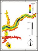
The seismic data of a designated wind farm area off Borkum reveals that the wind farm area is located above the eastern flank of an updoming structure, probably a salt dome. The flank is located in depth of 170 to 280 meters. The near-surface structure is quite heterogeneous and characterized by numerous filled channels, often cut into each other.
Project SD1: Formation and infill of buried Pleistocene tunnel-valleys in the North Sea
2009-2012
A. Bartholomä, J. Ehlers, T. Hanebuth, D. A. Hepp, T. Schwenk, V. Spieß
 The release of meltwater from the margins of the Late Quaternary Fennoscandian ice sheets resulted in complex networks of (now buried) Pleistocene tunnel-valleys that extend beneath large parts of the North Sea and the adjacent northern European lowlands. Deeply incised (100-500 m) into mostly Neogene sediment strata, they form a dominant architectural element of the North Sea sedimentary basin and are a primary cause of small scale lithological heterogeneities. Offshore mapping based on seismic surveys is far from complete, but has provided evidence of multiple generations of buried valleys, inferred to record at least three successive cycles of continental glaciation and interglacial marine transgression. The largest known buried valleys lie in and adjacent to the southern North Sea and have been tentatively correlated to the mid-Pleistocene Elsterian glaciation. The recent discovery by MARUM scientists of a so far unknown major E-W trending buried valley in the SE North Sea poses new multi-disciplinary questions with regard to the ages of cross-cutting features, their infill architecture and lithology, the orientations and dynamics of former ice margins, the number and nature of interglacial marine transgressions and the mitigation of geotechnical risks. The latter is of economic importance as lithological heterogeneities in shelf sediments induced by such valleys, common features also in other formerly glaciated regions, have recently gained attention in offshore wind park planning as potential geotechnical risks.
 To what extent are well-known N-S trending buried Pleistocene valleys in the SE-North Sea cross-cut by younger, but E-W trending tunnel-valleys?
Deep (>100-500 m) Pleistocene tunnel-valleys beneath the northern European lowlands (Denmark, N-Germany, Netherlands) and the SE North Sea commonly follow an overall N-S trend and their infill is capped by varying thicknesses of Late Elsterian Lauenburg Clay. Consequently, the formation of these valleys has been assigned to the preceding Elsterian glaciation. Similar structures formed during subsequent glaciations, although they are less extensive and not so deeply incised. The newly discovered E-W trending valley in the SE North Sea is more than 35 km long and apparently crosscuts older N-S trending valleys. Although exceptional for the moment, the presence of additional such valleys is very likely, taking into account the poor mapping status of the SE North Sea. As tunnel-valleys are thought to form by melt water drainage beneath and perpendicular to ice sheet margins, an E-W trending post-Elsterian valley in the SE North Sea implies a N-S trending ice margin of Saalian (?) age, which previously has not been proposed for the German North Sea sector but would fit observations in the Dutch sector. 2D/3D seismic investigations of the extent, shape, infill architecture and crosscutting relationships of Pleistocene buried valleys will be an important contribution to resolve the existing inconsistencies in describing past ice sheet dynamics in this region.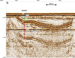
Figure 1. Seismic section through the recently discovered E-W trending buried valley in the German Bight.
Do different infill successions of N-S and E-W trending Pleistocene buried valleys in the SE-North Sea reflect different formation and infill processes?
According to seismic investigations and sparse borehole information, most buried valleys in the North Sea and the adjacent northern European lowlands are filled with a glaciofluvial backfill, deposited close to the retreating ice margin. Their upper parts often contain also younger well-layered muddy glaciolacustrine and/or glaciomarine sediments deposited during subsequent interglacial transgressions and glacial advances. Taking advantage of extensive (mainly industrial) core material and in-situ logging data resulting from wind farm site surveys, the infill lithologies, and thus the infill histories, of N-S and E-W trending valleys will be analyzed. By determination of the maximum pre-consolidation pressure the infill experienced, the ice and sediment loading history of these sequences can be assessed, thus allowing an estimation of e.g. the maximum thickness of Saalian ice advances having overridden the Elsterian and Holsteinian valley fills. In contrast, infills deposited just after the Saalian glaciation should not show any overcompaction as the Weichselian glaciation did not reach the SE North Sea.