2017 03 - R/V Celtic Voyager Cruise CV17013

Geophysical Exploration of the Shallow Sub-seabed (GESS)

28.03.-13.04.2017 - Irish Sea : Cork - Cork
Chief scientist: Dr. Andrew Wheeler (UCC)
Chief Seismic: Dr. Stefan Wenau
MTU Participants: Dr. Toth, Schulze, Daskevic
Groups involved
- University College Cork (UCC)
- iCRAG - Irish Centre for Research in Applied Geosciences
- Working Group Marine Technology/Environmental Research, Department of Geoscience, Bremen University (GeoB AG Spiess (MTU))
Instrumentation:
- Sodera micro GI (Generator-Injector) Gun 2 x 0.1 L
- Teledyne Streamer 220 m, 96 channels, single hydrophone groups
- MaMuCS Acquisition System
- Innomar SES 2000 (MTU)
- Geo-Source 400 sparker seismic system (UCC)
- SeaSPY/Explorer Magnetometer (UCC)
- Simrad EM2040 Multibeam (UCC)
The GESS survey was a collaborative survey undertaken by researchers in iCRAG – The Irish Centre for Research in Applied Geosciences, University College Cork and the University of Bremen (Germany). The aim of the survey is to collect geophysical acoustic data in the Irish sector of the Irish Sea and the northern Celtic Sea. The data set will be primarily used to improve the knowledge on the nature and formation of recent seabed sediments that were influenced by the Irish Ice Sheet during the last glaciation and to create a 3D geological model and revise existing sub-seabed models of the seabed sediments in the Irish Sea and the northern Celtic Sea.
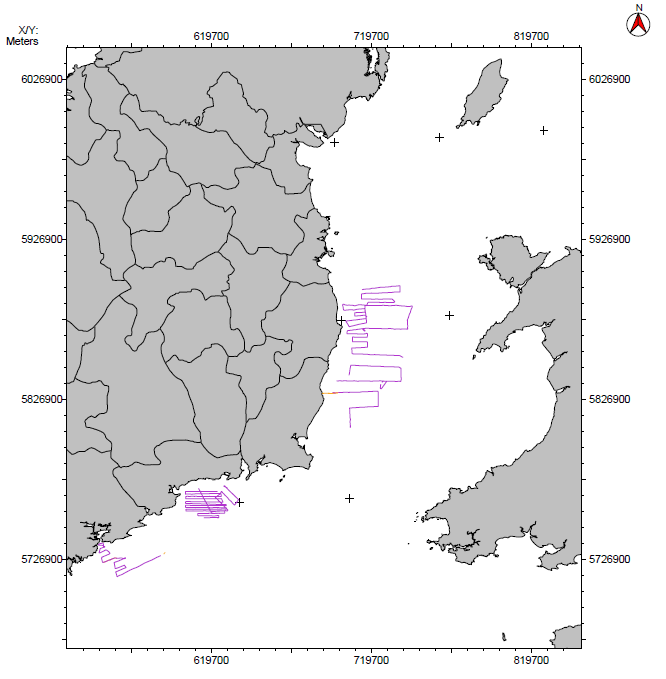
Seismic data were collected on R/V Celtic Voyager using the MTU multichannel seismic equipment. These data, along with INFOMAR multibeam echosounder data will allow for a robust evaluation for palaeoevalley systems off the south coast of Ireland. This project will target the offshore extension of the Rivers Bandon, Lee, Blackwater, Colligan, and Suir (Figure 1). These are known to contain valuable aggregate resources which will be quantified and aggregate quality assessed from samples. The offshore River Suir palaeovalley also allegedly contains pea gravel. The datasets collected will enable insights into palaeovalley development of the south coast and the geological development of these meltwater channels. As well as further our understanding of the Quaternary history of Ireland, such information provides a “geo-logic” enabling a greater understanding of, and aiding a predictive capacity for, further marine aggregate exploration.
Multichannel Seismic Data Examples from the cruise Track Chart of MCS Lines