
AL566 Logbook
15.10.2021 08:00
There is not much more to say: We arrived on time, even before 8, trucks were waiting, and equipment was quickly unloaded, rooms were cleaned and approved, backups were finished and packed and students left the ship. Last acition is signing the cruise report and comment sheet of the ship. It was a successful cruise, and extraordinary weahter, good data, and a lot of motivation for the upcoming semester and teaching, where some of the data will be used directly. We'll be back in September next year and looking forward to it!
15.10.2021 01:00
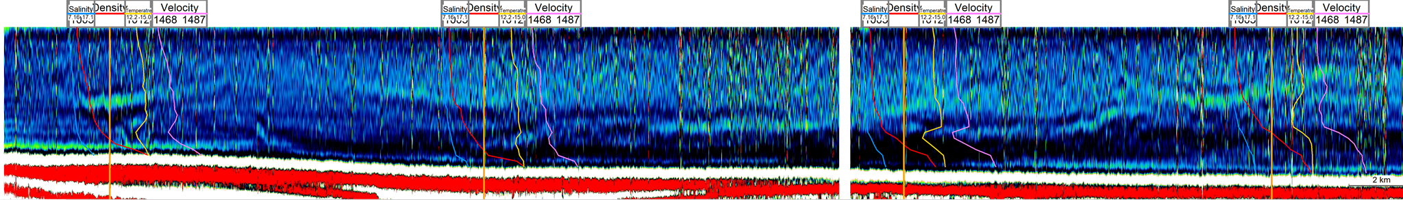
Shortly before lunch we started to retrieve the seismic gear and the side scan sonar and lifted the multibeam transducer in the moonpool. Subsequently, we started to pack our equipment on the one side, but, more importantly, started our station work with 5 CTD stations to measure water properties, to determine water masses and to correlate with our seismic data. Over the three legs, we now have a couple of seismic lines with clear water column reflections and 15 CTD stations across the whole Arkona Basin between the Danish Border in the East and Krieger Flak in the West.
Based on the nice seismic image of the water column reflection, we picked the station at places of different reflection strength and signature. There is clearly a strong lateral variation with respect to water masses and their properties, and the seismic data allow to spatially interpolate between them. We will include these data into follow-up student projects where of interest.
Around 17:00 we had to leave our working area to return to Kiel, without further geophysical experiments but rather packing the materials, which will be picked up in the morning at 8:00 by a truck.
(Volkhard Spiess)
14.10.2021 18:00
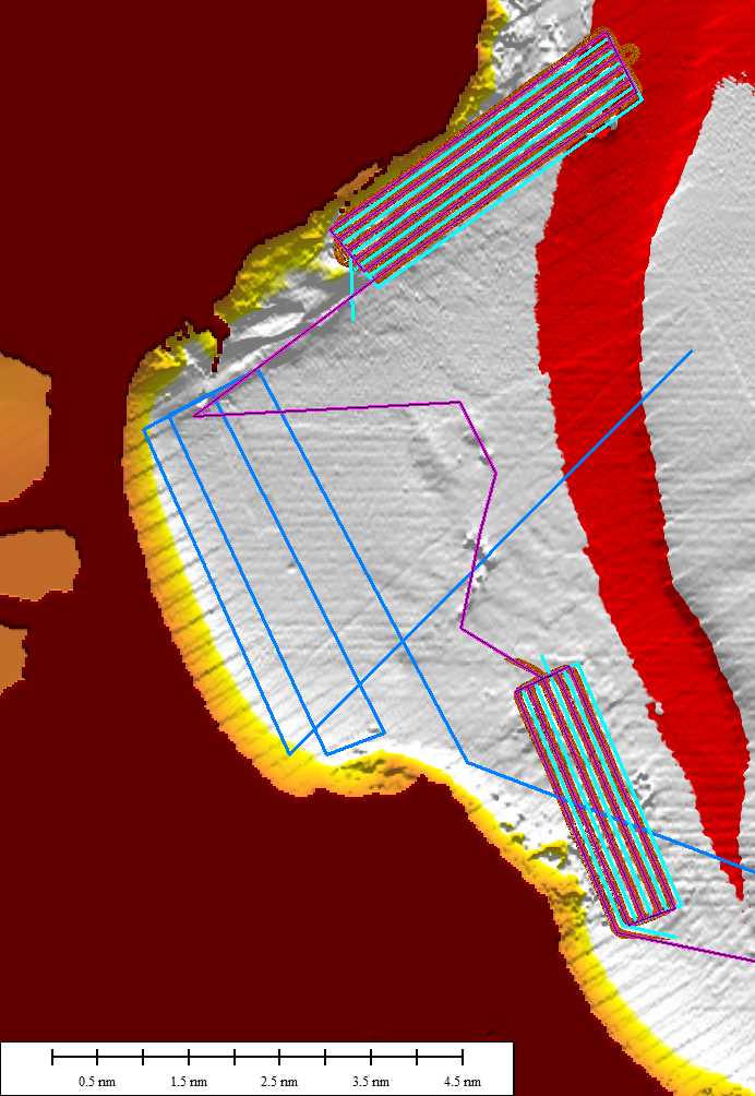
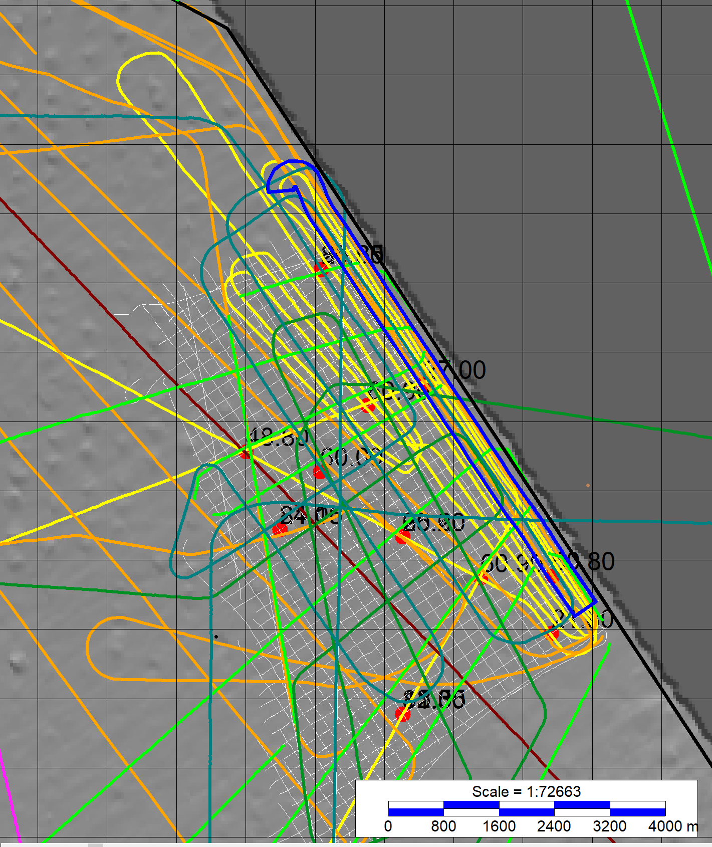 The long transect over night led us to the easternmost part of the German Baltic Sea at the Danish border. There we surveyed in an area, which is a dedicated wind farm area, just opened by BSH for bidding earlier this year. So, in the near future, there will be no more chance to collect scientific data within the park area, and we take therefore the 'last' opportunity for some dedicated seismoacoustic profiling. So, we surveyed the yellow lines in this year for a dense grid suitable for research.
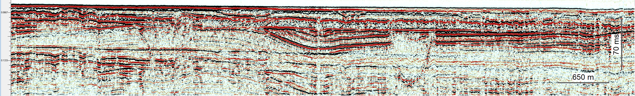
While the commercial data have been collected with a sparker source, which shows more details but lacks penetration due to its higher frequency, airgun profiles are complimentary. Our interest is particularly in the glacially-induced deformation, which is reflected by fracturing, detachment of blocks, freezing and deposition of glacial till. On one of our last seismic profiles for this year we can see a pronounced interruption of strata and an incision, which may hint to such glacial deformation. We plan to target these questions in an upcoming master thesis.
(Volkhard Spiess)
13.10.2021 22:00
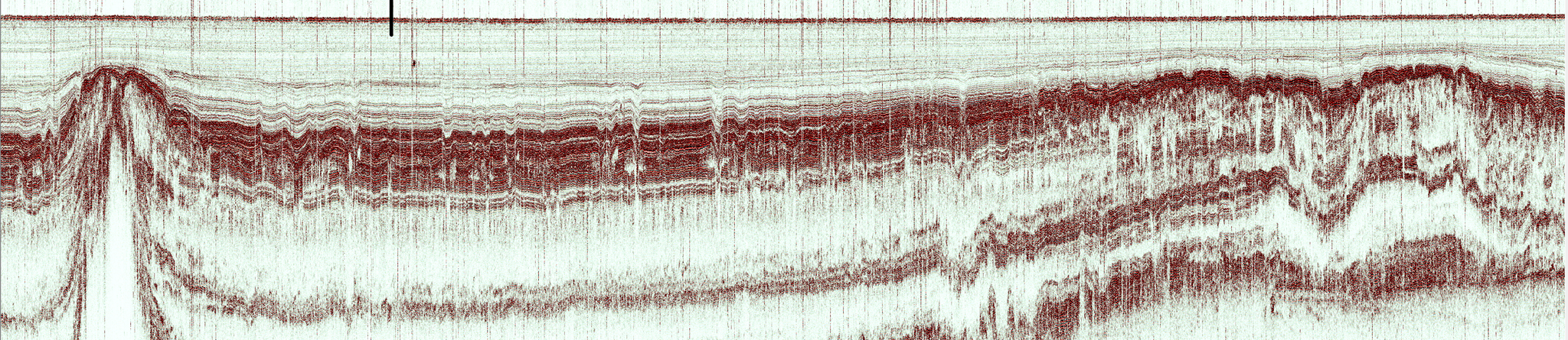
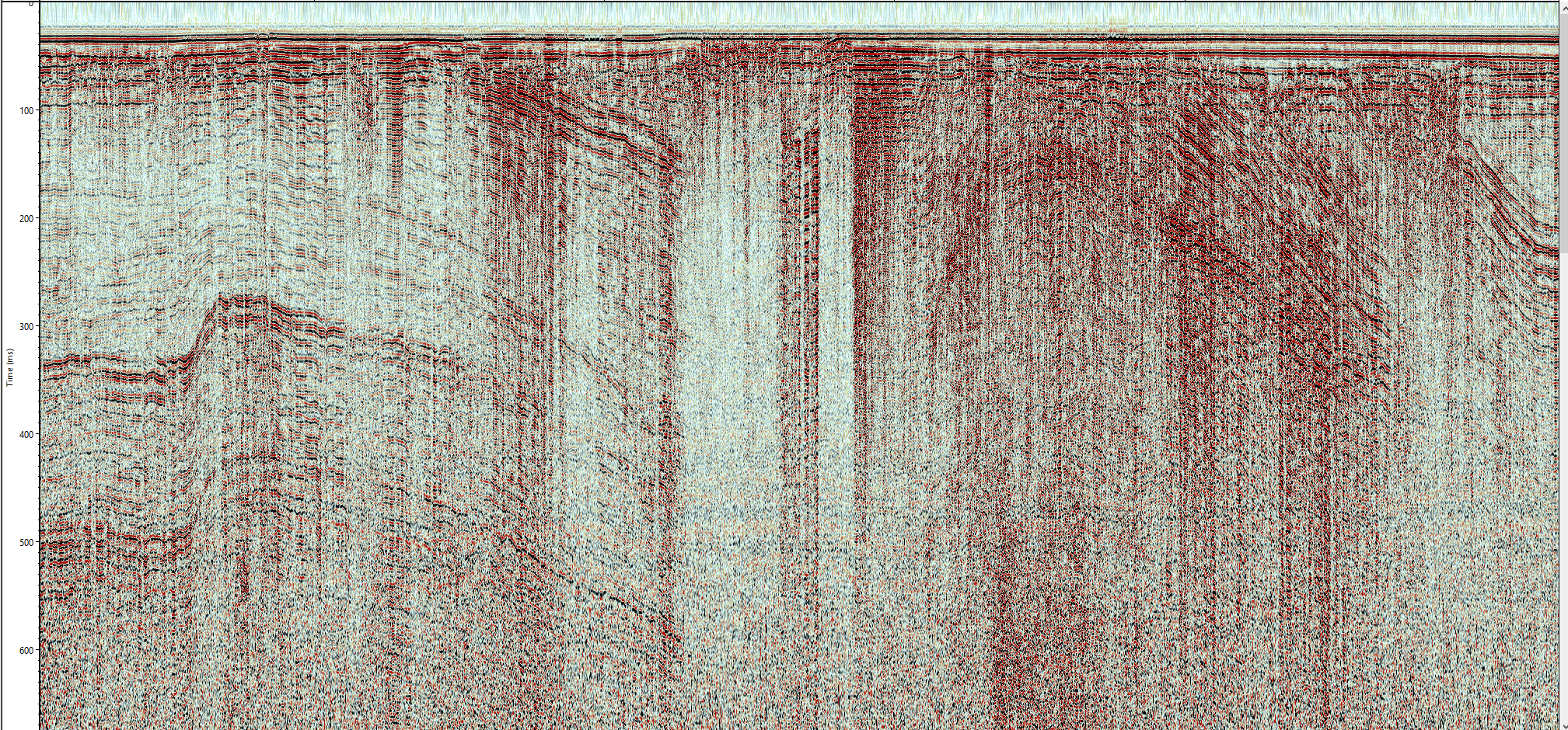
The water depth of Arkona Basin is more than 45 meters, and as such, it is a depositional sink for fine-grained material of clay and silt grain size. In the Holocene, the upper layer is therefore quite homogenuous and acoustically almost transparent. Sedimet echosounder data reveal a high level of detail in structure and in vertical, i.e. temporal changes. Back in time, in the late glacial, glaciers and river run-off has provided coearser grained material, which becomes visible by higher reflection amplitudes. The lower ampltidue unit below is, other than the upper two units, of constant thickness, which is likely related to an isolation of the Baltic Seato a lkae setting, the Baltic Ice Lake Stage.
It is noteworthy, that the seafloor is almost flat and horizontal, which clearly indicates the presence of bottom currents.
For the night, we will look into the water stratification, so that we can raun a couple of CTD stations, looking at water properties again.
13.10.2021 17:00
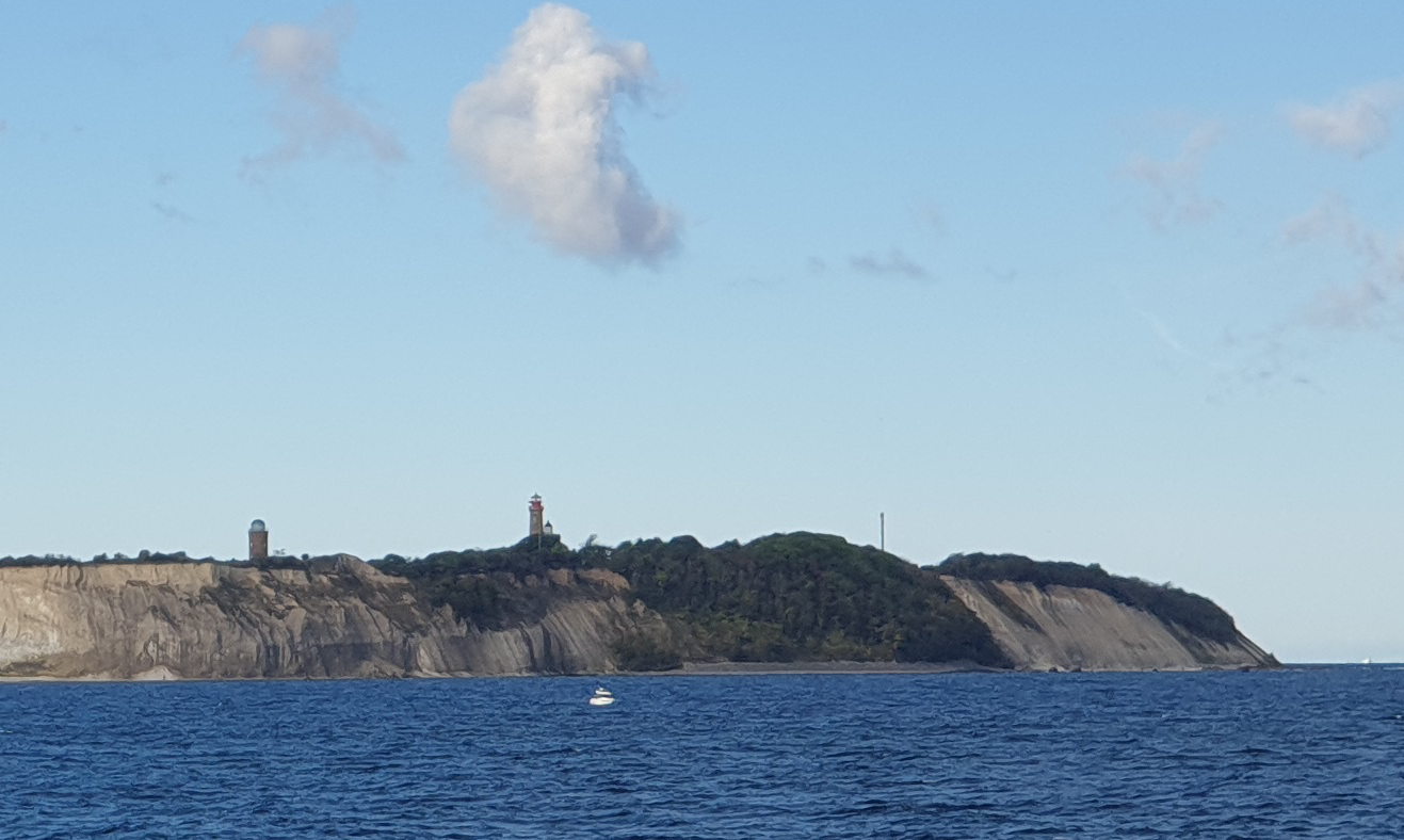
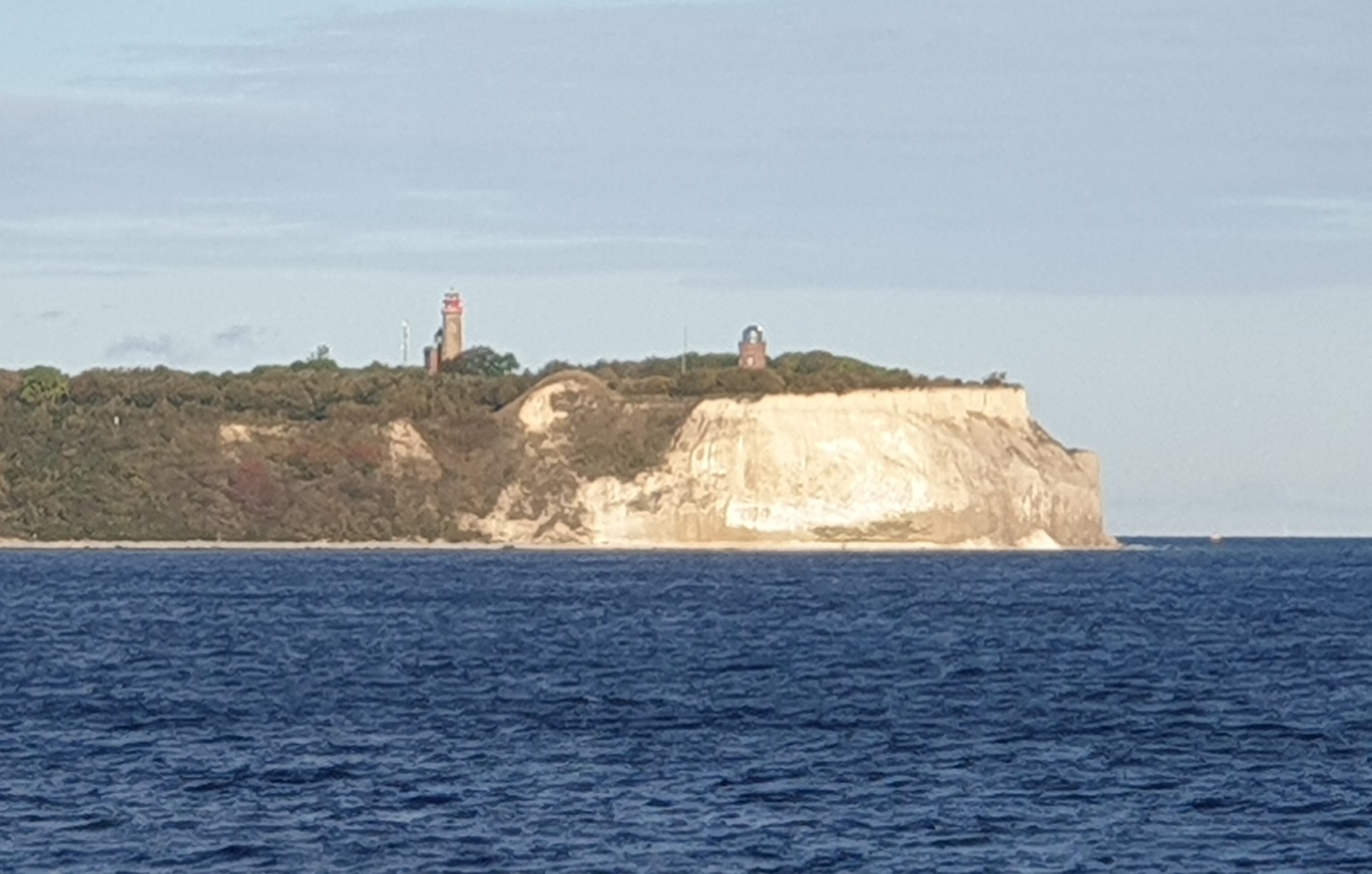 Kap Arkona is the windiest part of Rügen, but we were lucky to pass along it with nice weather and waves. Within Tromper Wiek, spectular features could be imagedalong the shoreline, which were likely relicts from glaciers streaming westwards through the Wiek. Lot of large boulder are found at the beach, some more than 3 m long. In the Wiek itself, sediment is covering the glacial landscape, even current-controlled deposits called contourites are found.
We are currently heading northwards, across a shallow barrier between Arkona Basin and Mecklenburg Bay. We have identified a possible throughflow region and we will try to find out with side scan, sediment echosounder and seismic, how it looks like and whether it might still be active and traces of this activitiy can be seen.
Next on the agenda is a long eastward profile across the Arkona Basin, which we will use again, like on Legs 1 and 2, to identify water mass boundaries and pick CTD station, from which we can correlation boundaries with seismic reflections in the water column.
(Volkhard Spiess)
13.10.2021 12:00
The survey program for Oct 12th day was dedicated to the Prorer Wiek with some focus on the part closer to the shoreline that we could not survey on previous cruises.
Prorer Wiek has been shaped by a strongly erosive ice-stream during the Northern Hemisphere Glaciation some 20'000 years ago, which at the same time also detached Cretaceous bedrock blocks and piled them up on Jasmund peninsula.
Remains of this deformation are not only found on land, but also drowned near the modern coastline. In some parts, these remains form shallow water reefs, which are habitats and reveal a high biologic diversity.
As an example of habitat mapping, which is classically carried out with side scan sonar, we have chosen two areas in the Prorer Wiek for a complete coverage spatial mapping. In between, the seismic lines should reveal more of the subsurface deformation, which we hope to combine to a full picture of the geologic evolution of the Wiek.
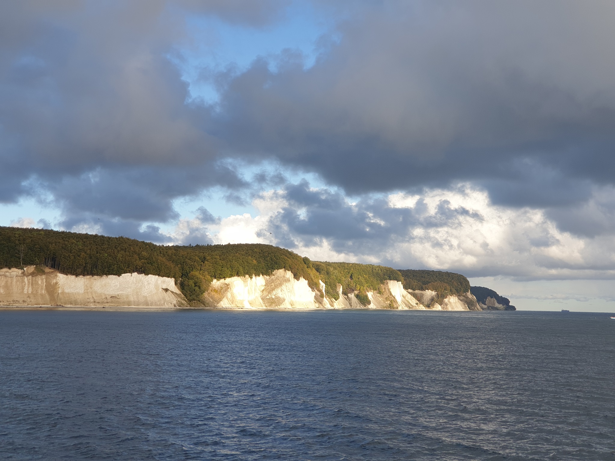
At night, we then continued to the North, following the shoreline off the chalk cliffs of Jasmund as e.g. Subbenkammer and Königsstuhl. Strong coastal erosion by waves is typical causing slope failave, even dangerous to people walking in autumn along the beach, and thn waves are gradually removing finer particles and glacial till and bould are enriched in this environment. Again this represents a rich habitat.
The side scn sonar lines along the coast are complimentary to the ones we collected during Leg 1, so that we now have a stripe of more than a km width, showing the transition from rocky shoreface to the sediment covered deeper basin.
The Tromper Wiek has likely the same origin as Proer Wiek, representing the path of a ice-stream continuing deep into land. We are collecting first side scan sonar data and seismic lines close to the shore, which we hope to compliment in following years. In the afternoon we will reach the central Arkona Basin.
(Volkhard Spiess)
12.10.2021 11:00
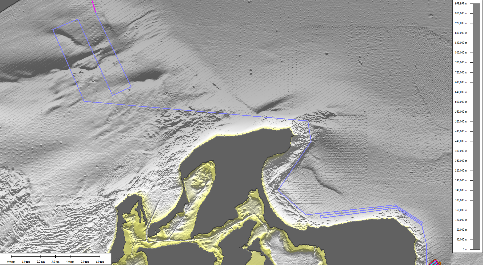
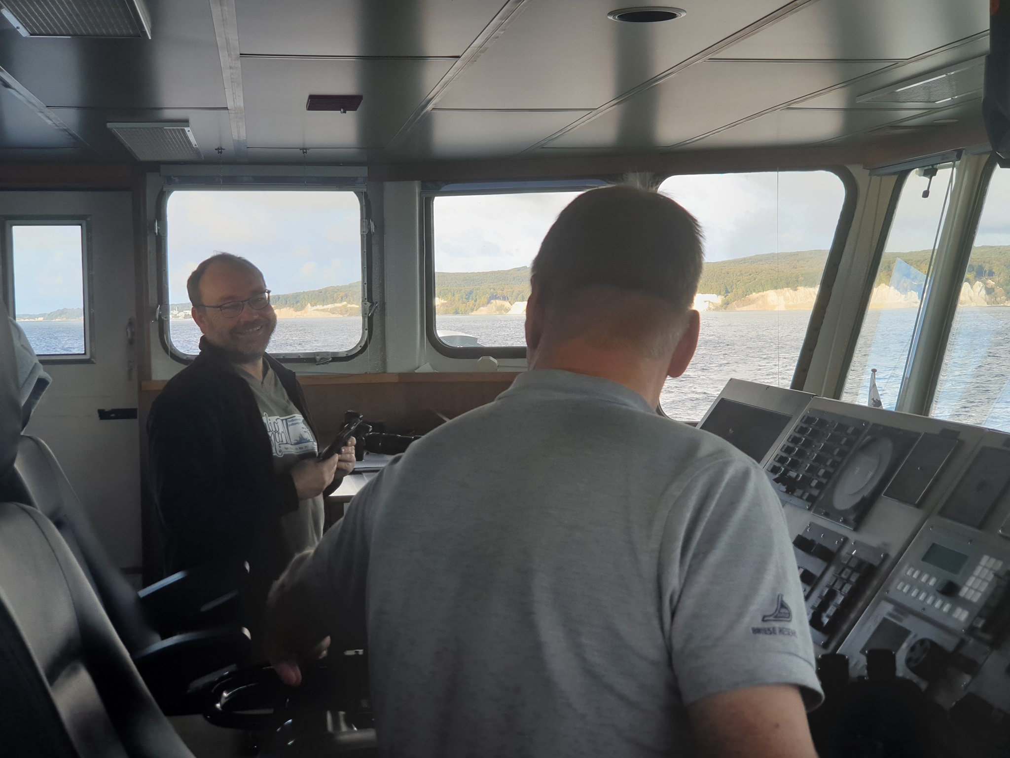 Leg 3 started with 6 student participants at 8:00 in the morning. First item on the program was the continuation of a survey, which we finished half at the end of Leg 2. It was located right in front of the chalk cliffs and the old city of Sassnitz. We are trying to cover a complete area of 5 km by 1.5 km with parallel tracks and side scan sonar swath width of 300 meters. The results could be used as a habitat map to document the environment for life, but of course this information can also be used for geologic interpretation. The Jasmund chalk cliffs are the result of glaciotectonism, i.e. the glaciers have detached large blocks of the chalk bedrock from the ground and piled these pieces up to make a >100 m high peninsula. How exactly these structures extend seaward, is basically unknown and the target of this and the following surveys of today. Later today we will also deploy the multichannel seismic equipment for deeper subsurface imaging.
(Volkhard Spiess)
11.10.2021 15:00
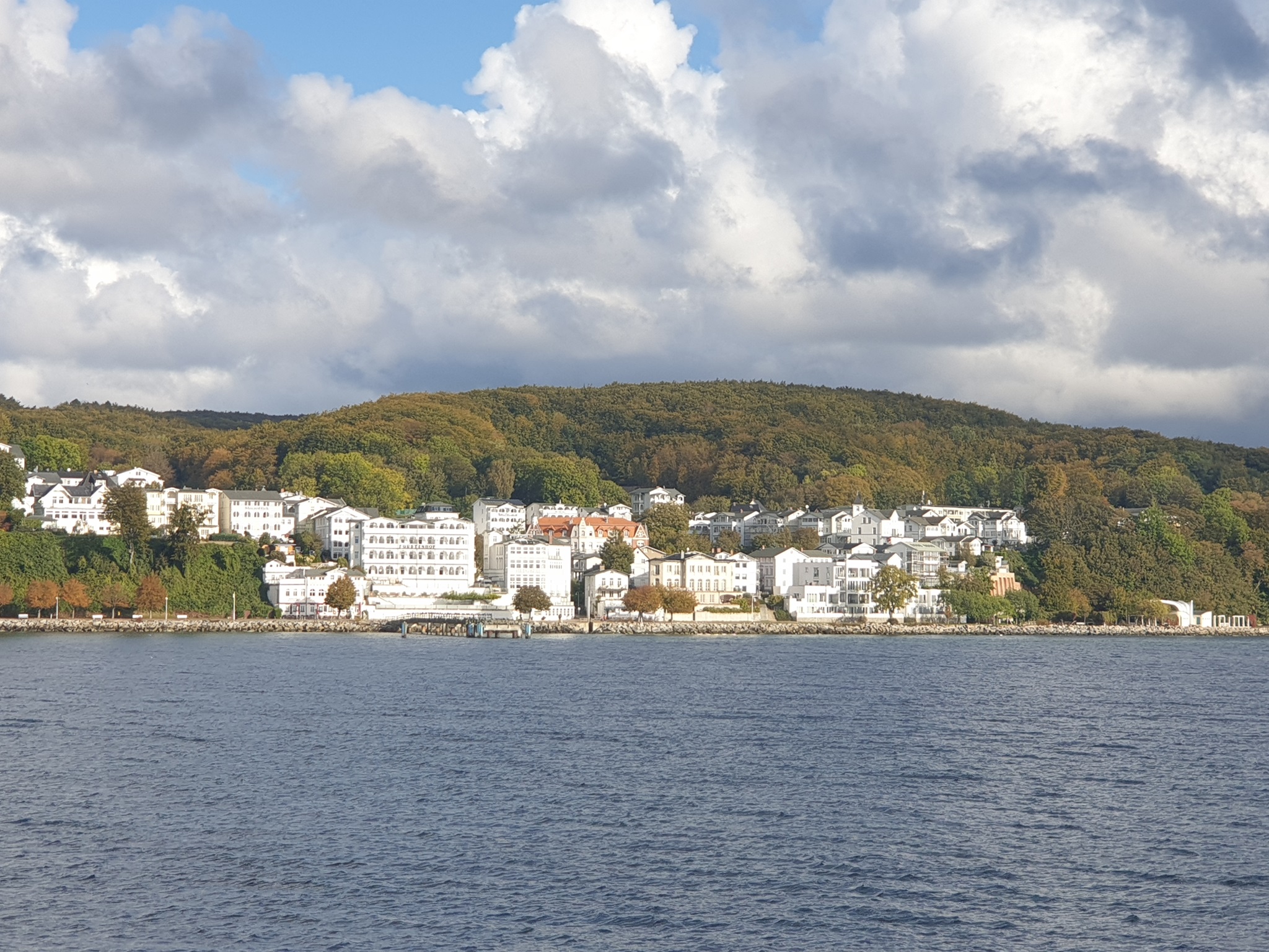
 Back in Sassnitz for the port call and crew exchange!
And we bring back a rich collection of geophysical data, where we can learn about artifacts and geologic features on the Baltic sea floor.
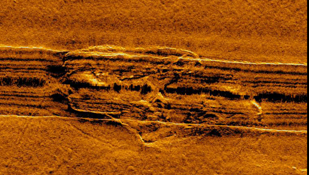
 This collection shows a boulder (?), fish, an electric wind farm power cable and its crossing with the Nordstream 2 pipeline. Typically these objects are monitored in commercial surveys to ensure that they are safely positioned, sediment covered if necessary, and the location is exactly known.
 The last evening yesterday we had to pack part of our seismic equipment, since it is transferred to another cruise on the North Sea, which is going to start tomorrow. Only the acoustic instruments - side scan, sediment echosounder and high-frequency echosounder plus multibeam were in operation.
Our frame was disassembled, and we will continue our seismic campaign with a shorter new streamer and just an airgun source.
A truck loaded the equipment heading for customs and Bremerhaven lateron.
Tomorrow at 8 we will start our next leg with another group of students for about 2.5 days of survey work, before we for the final destination of Kiel in the evening of Oct 14th.
(Volkhard Spiess)
10.10.2021 15:00
 Today in the morning we arrived in the area, where both the two Nordstream pipelines enter Greifswalder Bodden, but also the power cables, which are connecting the Baltic windfarms with land. After surveying the whole area with sidescan to precisely locate the different man-made objects and distinguish them from geology or fishing ploughmarks, we then designed a survey with our experimental frame, to collect data to also locate these objects if they are buried by sediment. This is a research goal of an ongoing project and will be used to design our data processing and interpretation software.
Right now we are measuring the sound emission field of a sparker system, which is useful to evaluate the noise emission relevant for marine mammal protection, but also to know better the energy distribution as a function of angle. This information is crucial if we want to quantify soil properties, and such data is not yet available.
(Volkhard Spiess)
09.10.2021 15:00
Another beautiful day on the Baltic Sea! Over the 20 years of student cruises, this is probalby the one with the best weather conditions. With the exception of a few hours on Leg 1, we had wind of Bft 4 or less and small waves only, perfect conditions for equipment testing, which was very successful yesterday.
Over night we collected some more data in the Arkona Basin and across future windfarm areas, where we will not be able to collect seismic data in the near future. But we were also interested in the soil conditions and how they are related to glacial processes, which have shaped the landscape by erosion, freezing, thrusting and deposition of glacial tills.
And like on Leg 1, we also looked at the water column with our seismic systems, since variations in water properties may also cause reflections. Water masses in the Arkona Basin are partially derived from saline water intruding from the Kattegat into the Baltic Sea, with distinctly different properties. Thus sharp water mass boundaries develop which can be detected. Another 5 CTD stations were run during the morning until early afternoon, to measure those properties and compare them with the seismic data.
Subsequently we deployed the suite of instruments again, i.e. multichannel seismic with GI Gun, magnetometer and side scan sonar, and continue profile from the Arkona Basin at night the Greifswalder Bodden in the morning, where we intend to map pipelines and cables.
(Volkhard Spiess)
 08.10.2021 20:00
That was a really long and successful day!
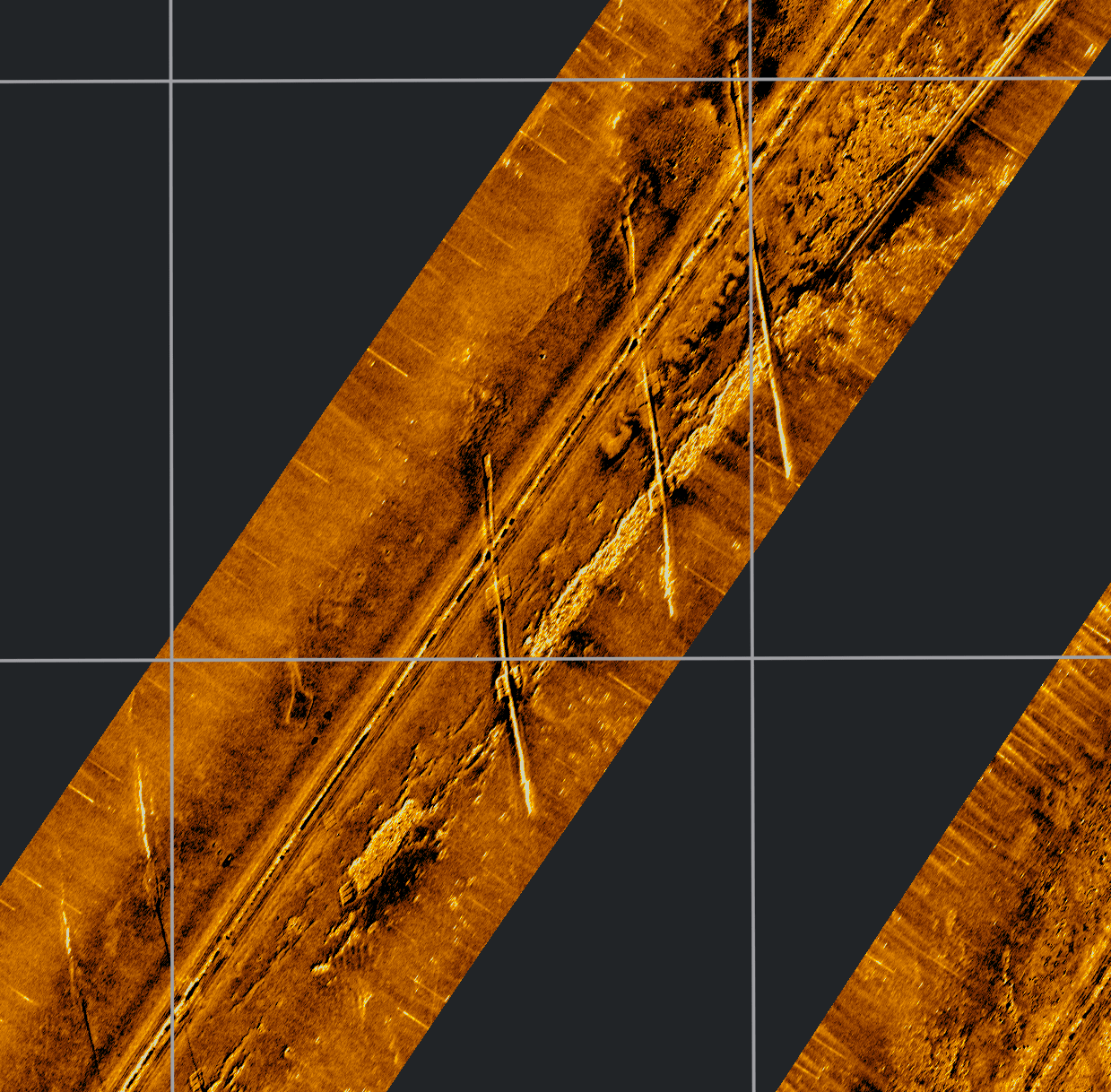
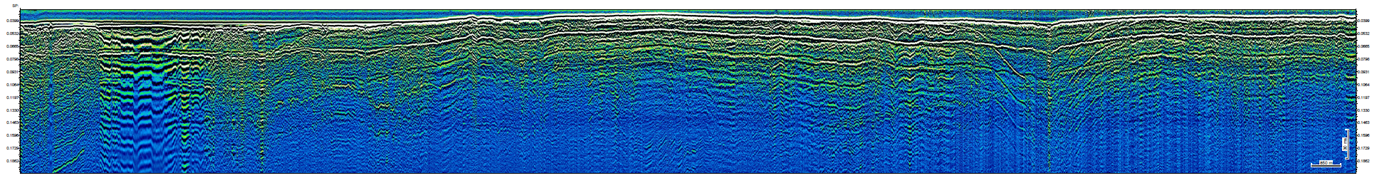
Last night we crossed one of the major tectonic zones in Northern Europe - the Sorgenfrei-Tesseire-Tornquist Zone, which separates the sedimentary rocks of Northern Europe and the North German Basin from the Baltic Shield. While this has been a subduction zone with thick Cretaceous sediments accumulating, the collision of two continents led to faulting and uplift. Major normal or reversed fault zones can be recognized in the seismic line, although they appear more like folds in the shallow part, where softer sediments were deformed. The line reached from Greifswalder Bodden to the Polish border, where we turned back and followed the Nordstream Pipeline.
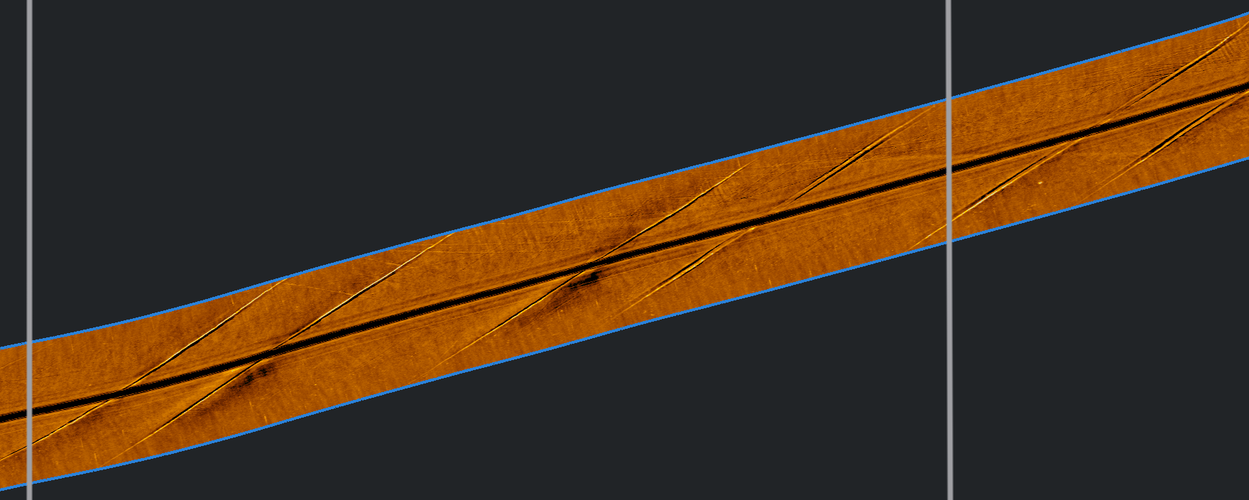
Manmade objects are always a target of geophysical investigations, to localize them, the check their status and to determine any dynamic changes, such as currents, sediment transport etc. We used our different systems to analyze the geophysical signature, including the magnetic field of the pipes. We learned, that they are not positioned exactly where they are plotted in charts, that they can have a different magnetic field at different segments, and that the recognition depends on sediment burial and the contrast to the surroundings.
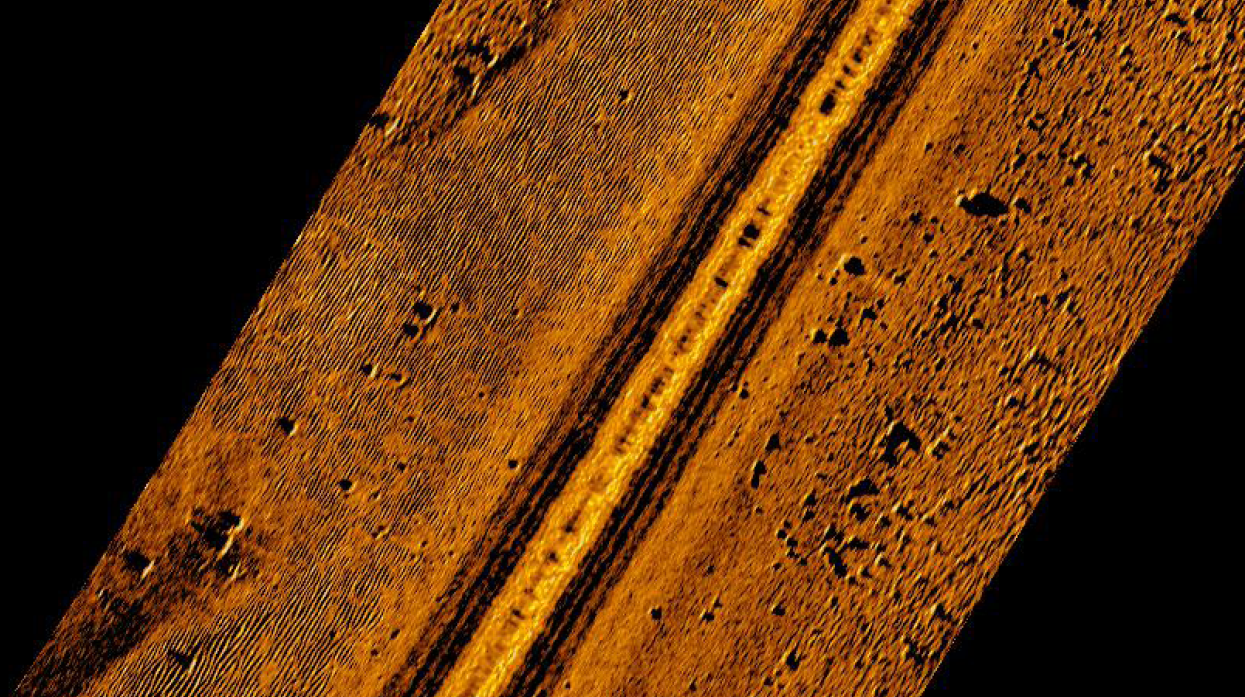
 Continuing to the West, the second technical object to survey was an electrical power cable which was layed out in recent years to connect wind farms in the very East of the Arkona Basin with land. These cables need to be monitored because of the shallow depth and their temperature history. We were able to clearly recognize and follow the cable in side scan sonar data. Of particular interest is a newly layed cable right when we were passing the area earlier this week. This cable is partially not yet buried or nto in a trench, and we can learn about the differnece in backscatter signature. We also picked this as a target for our seismic frame, which is an experimental version of an acoustic object detection system, using high frequencies to also identify linear objects as small as cables. The test survey with the frame took the whole afternoon, and everyone was tired, when it came back on board around 7pm.
Following night will keep us busy with seismoacoustic and magnetic profiling. The last profile next morning will be chosen to look again at the structure of the water column in the Arkona Basin and to chose CTD stations a a followup, to confirm the nature of reflections in the water column - an approach we call seismic oceanography.
(Volkhard Spiess)
07.10.2021 20:00
 After the test, we are now continuing with our longer streamer, which allows a better and deeper imaging, targeting the rocks buried in the Pommeranian Bay. For the deployment, all hands are needed on deck to particpate in or follow the procedure, since this will not happen very often during a cruise. A little bit of maintenance is need, e.g. renewing tapes, and the cable levellers (=birds) are attached to the streamer, which will automatically control the towing depth by adjusting their wing angles.
But before we can start generating sound, we are taking care of livestock around. One of our crew members is observing the water suface from the bridge to ensure that no marine mammals are around, which could be hurt by the loud sound of our seismic sources. After this period, we are slowly ramping up the acoustic energy so that animals can escape from our position not to be exposed to the noise. Only then we start profiling. However, we are so rarely observing mammals near the ships, also because e.g. harbour purpoises are not common in our working area.
The track brings us close to the exit of the Greifswalder Bodden, which is geophysically very interesting, because both a newly laid submarine power, connecting to wind parks in the very East, can be crossed and the Nord Stream pipelines.. Both have a clear signature in seismic, sidescan, bathymetric, echosounder and magnetic data. And monitoring the position and burial depth of cables is an activity for many commercial survey companies.
Currently we are profiling towards the Polish border into a different geologic setting of the bedrock. Intense inversion tectonics has created a set of complicated fault zones, which also tilted the strata, and expose in some areas much older bedrock.
(Volkhard Spiess)
07.10.2021 12:00
 Another beautiful day in Sassnitz and at sea!
We left the pier at 8 in the morning, to prepare the test for a new piece of equipment, a light-weight streamer, just 50 m long with 24 recording channels. The test is just running now, and it looks fine, so that we started the first profile around noon time.
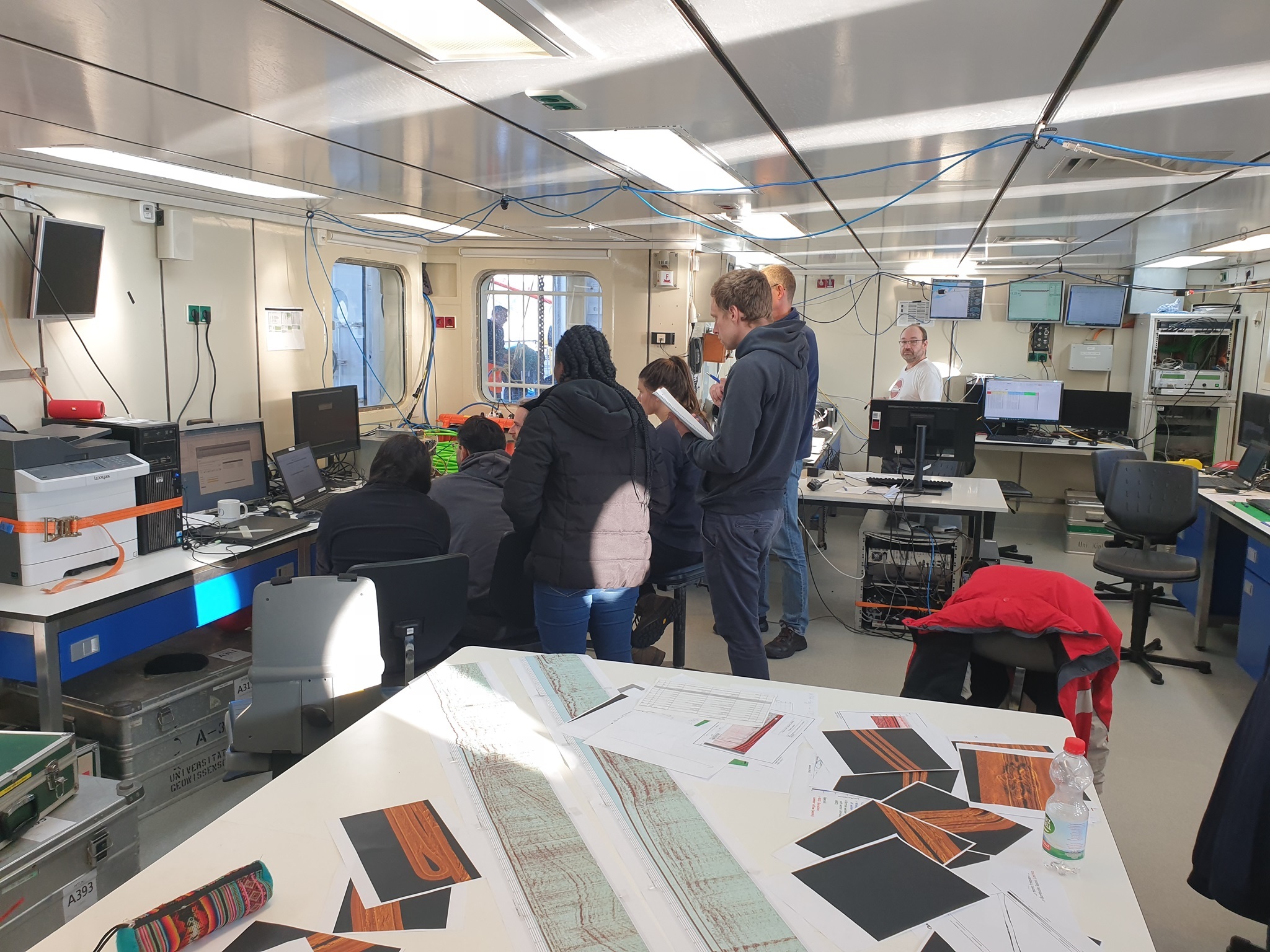
In parallel, the new crew was introduced to all the equipment on deck and the control computers in the lab, which have to be watched during watchkeeping. We are running our work on a 24 hour schedule to make best use of the valuable ship time, donated to us every year by the German Research Vessel Fleet for educational purposes. The watches are manned with two people for a period of 4 hours, twice a day. That ensures that instrumentation is constantly monitored for malfunctions and data quality.
But at the same time we also run a preprocessing of the data, to view them for scientific purposes. As seen in the lab on the table, seismic lines and side scan sonar data are displayed and compared with literature to carry out some very preliminary interpretation.
This information will also go into the cruise report, which the students have to write as part of their obligations for the course.
(Volkhard Spiess)
06.10.2021 16:00
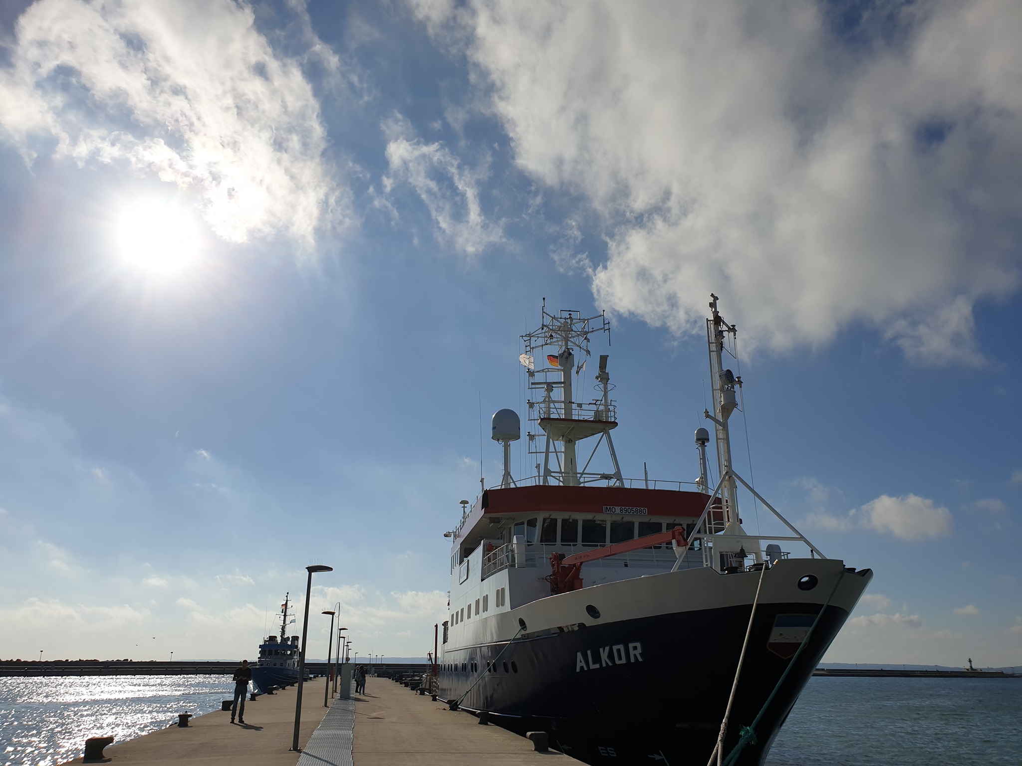
 R/V Alkor in the harbour of Sassnitz.
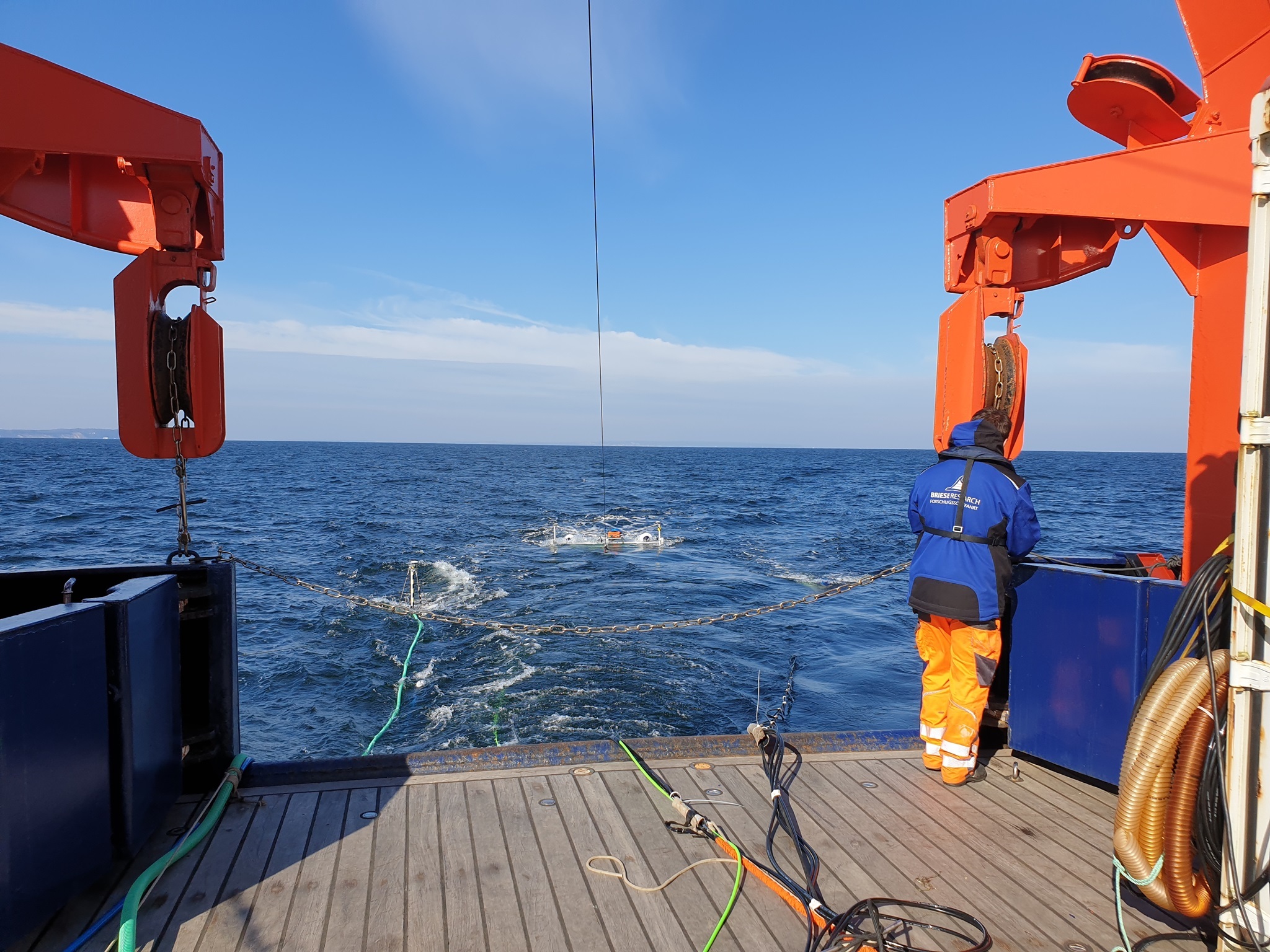
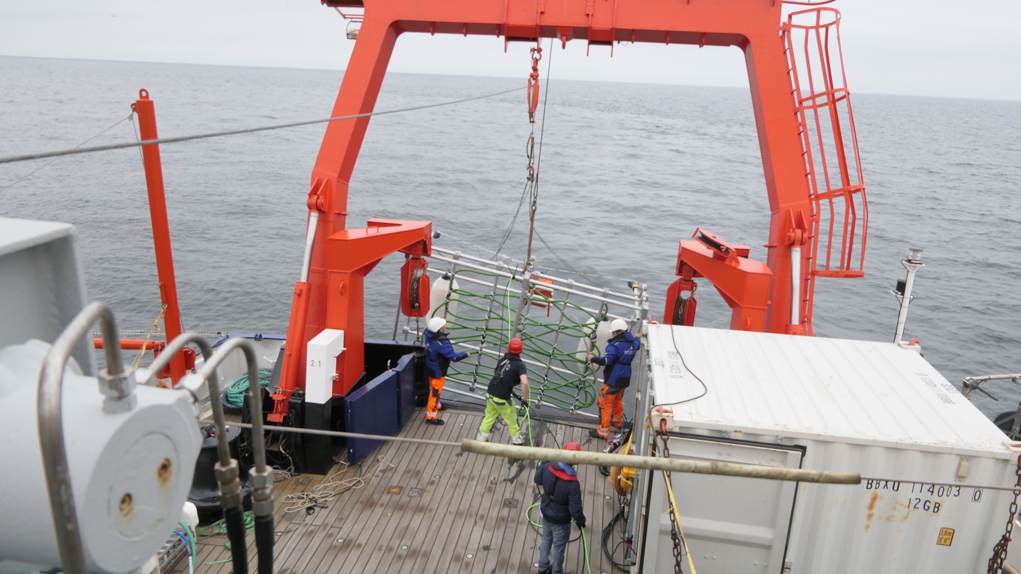
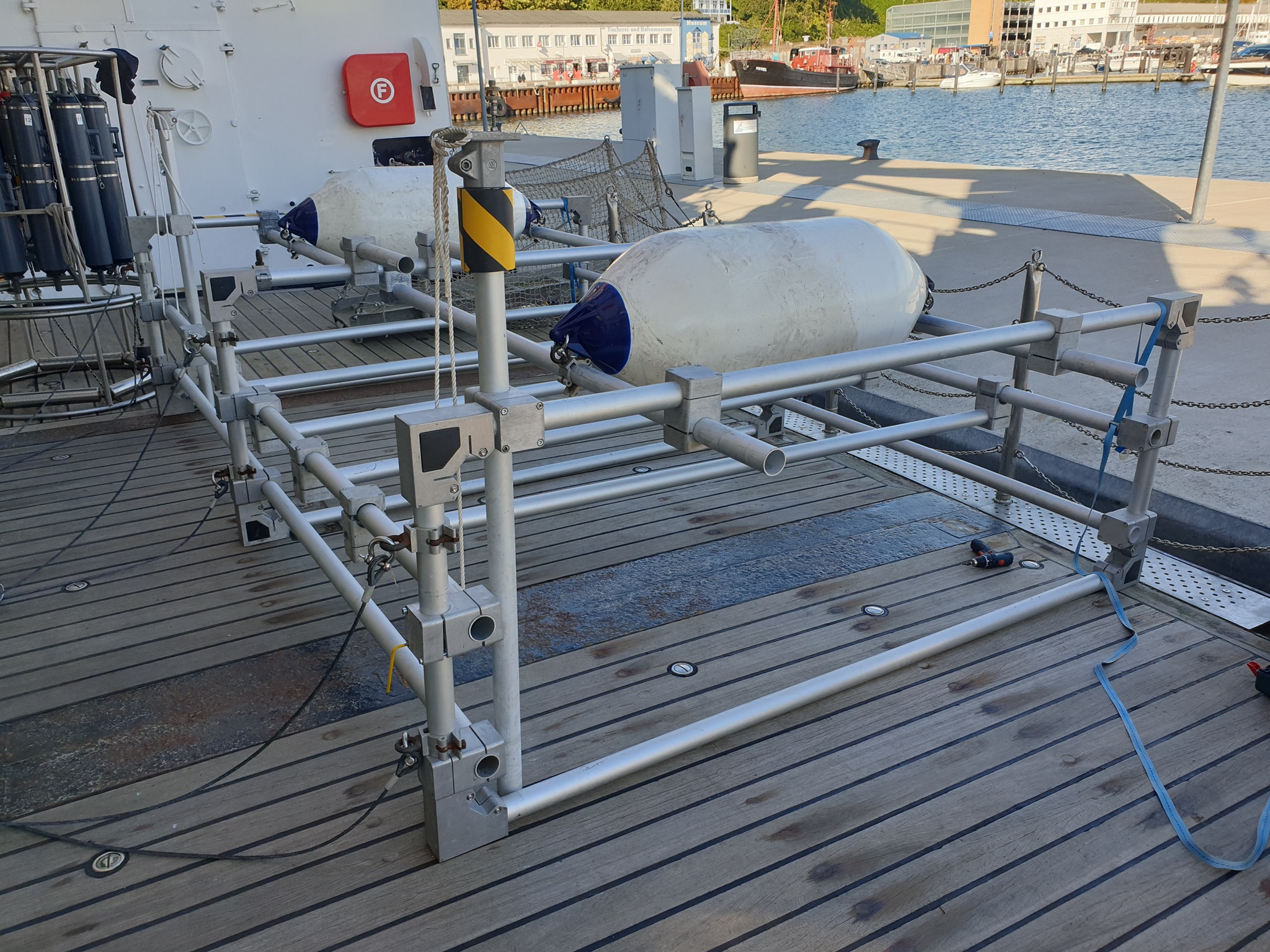
One of the interesting things to do is to test a new piece of equipment, a seismic frame, which will be used in a funded research project lateron. To prepare for this, we are currently assembling the frame, and afterwards, a streamer will be attached, which then allows to record seismic signals at different positions distributed over an area. Similar to a transducer, we can then use it to do 'swath seismic' similar to a multibeam system, where a swath of acoustic returns from the seafloor is used to create a topographic map. The seismic frame goes one step further and also allows to look into the seafloor, because the signals we use from sparker and airgun do significantly penetrate. We hope to be able with this setup to locate objects of all kinds at and beneath the seafloor over several tens of meters width.
But first we need to test, and this is among many other activities on the program for Leg 2 or the AL566 cruise. Tomorrow we will start early with the next survey - the weather forecorst is perfect for the next 2 days, like today in Sassnitz.
(Volkhard Spiess)
06.10.2021 08:00
 While we carried out our station work, weather was changing, and we were glad to finish before the wind reached Bft above 6. For a couple of hours, wind and waves were quite strong due to easterly winds. But weather forecast was pretty good so that we decided to continue surveying after the stations.
CTD measurements nicely confirmed what we had seen in the seismic profile, and 3 different water masses could be detected from the characteristic combination of salinity and temperature. Temperatures in the well mixed surface layer were still relatively high with almost 16°C, but bottom water was much colder. One water mass can be assigned to some event which occurs in summertime, when very warm but saline water is pushed from the North to the Baltic Sea. There it sinks but remains above the cold bottom water. These 'Baroclinic Summer Infolows' are wll known and could be identified in the vertical profiles.
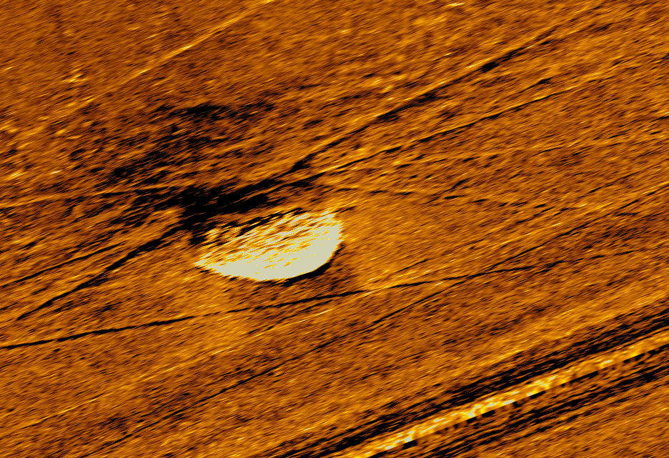
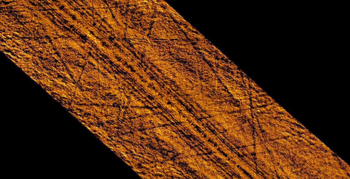
Being in the Arkona Basin, we visited locations which had been studied in previous years around some subsurface anomalies in seismic amplitudes and topography, socalled ppckmarks. Those may originate from ground water flow as in Eckernförde Bay, or from gas realease, wherever free gas can drive upward flow. Circular depressions are indicators, and in active systems also surface expressions can be seen, e.g. traces of life, concretions and high backscatter from acoustic instruments. While the topography shows clear depressions at the two sites, the sidescan sonar did only show minor backscatter anomalies, which probably confirms, that these 'pockmarks' are currently not active, but rather filled with fine-grained mud.
The last part of surveying of Leg 1 of our AL566 student cruise led us to the Chalk Cliffs, which can be found around Jasmund Peninsula on Rügen Island. These spectacular cliffs have an offshore extension due to wave erosion, and rocks are outcorpping even at some distance from the shore. So we ran a sidescan survey from Glowe to south of Kollwiekerort to study the nature of the seafloor and map the transition between hard grounds and softer sediment fill. This survey was finished at 8 in the morning, so that we could get into port in time at 10 o'clock.
The remining time we will use to wrap up the results with the students, to do some data backup and to take a little rest, before the second student crew will arive in the afternoon.
(Volkhard Spiess)
05.10.2021 12:00
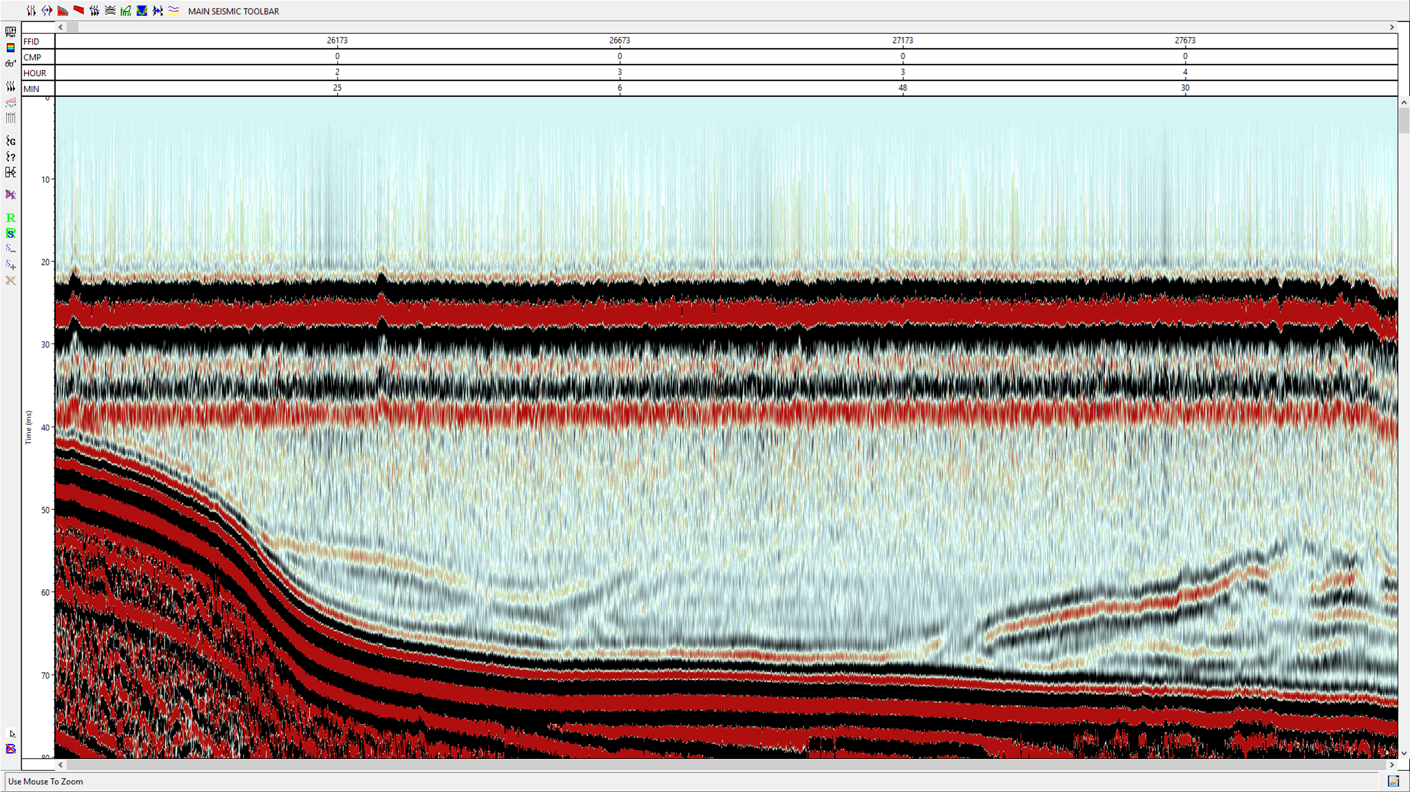
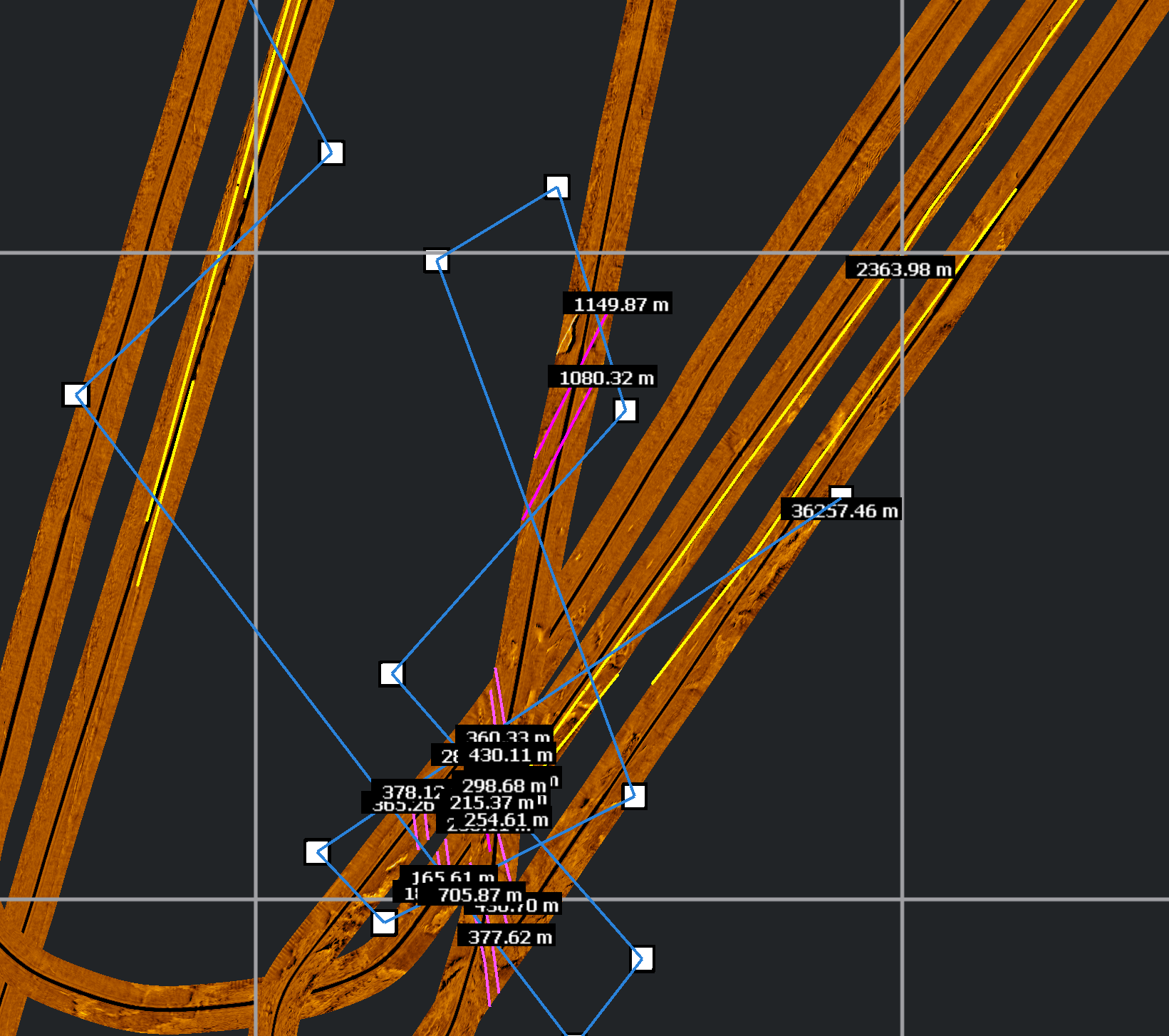
 Next on our agenda is station work. During the night, we passed the topographic barrier between Meckenburg Bay and Arkona Basin. On our seismic lines GeoB21-067+068 we cannot only see the seafloor, but also reflections above, which originate from changes in physical properties of the water itself. This is mainly related to temperature and salinity. Typically during autumn storms, but sometime also in summer, saline North Sea water enters the Baltic Sea and due to its higher density - its colder and more saline - it sinks to the bottom and travel far into the Baltic.
We can pick up these water mass boundaries in seismic data, and now we will use our CTD onboard equipment to measure the water properties and find out, which water masses the different units belong to.
After this station work, which will take us into the afternoon, we will continue with acoustic surveying with sediment echosounder, water column sonar, multibeam and side scan sonar.
(Volkhard Spiess)
05.10.2021 00:00
 On our way to Arkona Basin we continued the long seismic and acoustic survey, combined with magnetometer, du get the geologic overview of the North German Basin offshore. The data resemble the long geologic history from Zechstein Salt to Creatceous, with different rock types and tectonic deformation. While our seismic system is designed for high resolution, using a very small airgun of only 0.1 L volume, we can still image the upper 500 to 1000 m of the subsurface. Mecklenburg Bay was passed in the afternoon, where we could still find salt-related deformation of Cretaceous layers. Further to the East, salt is absent.
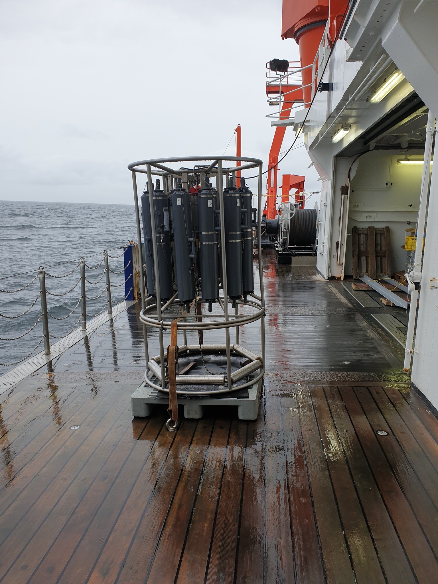
In the evening we did an interesting sidescan survey in the Kadettrinne, which is an incision of >25 m depth. To the East, water becomes shallower again, before we reacht after midnight the Arkona basin. This is an oceanographically interesting area, since salty water can pass through this basin, when North Atlantic and North Sea weather condition with strong westerly wind force surface waters into the Baltic Sea through the Kattegatt. Then the salt water dives into the basin due to its higher density, compared to the warmer fresh water in the Baltic Sea. We are planning for today some water column measurements using a so-called CTD instruments to determine conductivity, Temperature and pressure, from which we can calculate salinity and sound velocity.
On several stations we will run this CTD to find out more about the water stratification, which in turn may tell us something about the bottom currents. Those can transport sediment particles laterally and deposits them in so-called contourite deposits, which are known from Arkona Basin, Bornholm Basin and other parts of the Baltic Sea.
(Volkhard Spiess)
04.10.2021 15:00
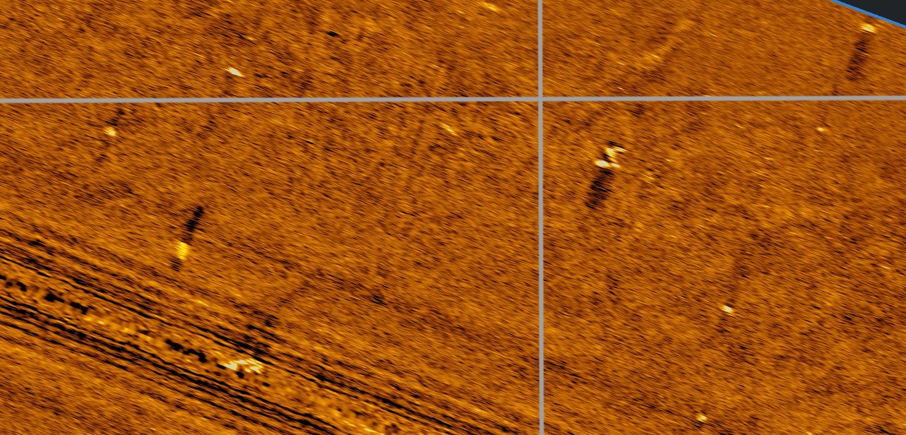
In the meantime we have smoothly passed Fehmarn island and through the corridor, which was defined for the construction work of the Fehmarn-Denmark tunnel. The sidescan data were processed in a very preliminary way and show some nice structures such as a pockmerk of groundwater outflow in Eckernförde Bay, sand ripples and dunes west of Fehmarn or scratches of fishing gear in Meckelnburg Bay.
The seismic survey imaged both very shallow features, but also the deeper subsurface down to 500 m to 1000 m, depending on the rock type. In Kiel Bay, e.g. surface depressions were filled by Holocene mud, which eventually produced methane gas from bacterial processes. At the same time still active salt tectonics in Pleistocene has affected the evelations together with the erosive forces of glaciers from the last glaciations. A distinct valley is seen west of Fehmarn, which is today completely filled with sediment.
(Volkhard Spiess)
Pockmark Eckernförde Bay Ripple field and stones off Fehmarn Scratches from ground fishing gear
Salt Holocene mud+gas shallow rugged seafloor glacially formed Kossau valley
03.10.2021 22:00
At at 8 in the morning, as planned, we left the port of Kiel with lots of equipment installed on deck and in the labs. First thing to do was to test our newly acquired side scan sonar system, which has not been in the water before. So we went to Eckernförde Bay, which is an geologically intesting place due to the presence of pockmarks and groundwater seepage.
The test was very successful, we are learning how to operate the winch to adjust the flying height of the towfish and to understand all the parameters for acquisition and display. It takes a while to view the data but so far we are quite pleased.
Since the early afternoon we are now also running the other equipment, which is multichannel seismic and magnetometer, for some longer survey lines in the Bay of Kiel, until we leave the area around Fehmarn during the night.
(Volkhard Spiess)